Bug report #13779

symbols not correctly clipped in map legend
| Status: | Closed | ||
|---|---|---|---|
| Priority: | High | ||
| Assignee: | - | ||
| Category: | Map Legend | ||
| Affected QGIS version: | 2.18.4 | Regression?: | Yes |
| Operating System: | Easy fix?: | No | |
| Pull Request or Patch supplied: | No | Resolution: | end of life |
| Crashes QGIS or corrupts data: | No | Copied to github as #: | 21805 |
Description
New description:
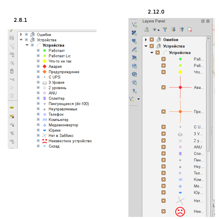
in QGIS >= 2.10 the legend shows the symbology too wide/high if the symbols are large/high. This was partially fixed in 2.12/master where this symbols are clipped vertically but not also horizontally, as it was for qgis <= 2.8.3. Sample images attached.
Old Descriptions:
corrupt symbols in the Layers Panel
This is seen in the video:
QGIS version
2.12.0-Lyon
QGIS code revision
exported
Compiled against Qt
4.8.6
Running against Qt
4.8.6
Compiled against GDAL/OGR
1.11.2
Running against GDAL/OGR
1.11.2
Compiled against GEOS
3.4.2-CAPI-1.8.2
Running against GEOS
3.4.2-CAPI-1.8.2 r3921
PostgreSQL Client Version
9.3.4
SpatiaLite Version
4.1.1
QWT Version
5.2.3
PROJ.4 Version
480
QScintilla2 Version
2.8.1
This copy of QGIS writes debugging output.
History
#1
 Updated by Giovanni Manghi over 10 years ago
- Target version deleted (
Version 2.12) - Category set to Symbology
- Status changed from Open to Feedback
Thanks for the cast, maybe I'm missing something obvious but I'm not really getting where the issue is, could you please try explain me? maybe attaching a small project with a small sample dataset? Thanks.
#2
 Updated by Alexander Novoselov over 10 years ago
- File qq.tar.gz added
#3
Updated by Giovanni Manghi over 10 years ago
In the project you attached what I see in the layers panel is the exact representation of the point symbols as you defined in the vector properties, no corruption. There are two symbology classes that are a represented by a circle and a wide cross, in the legend you can partially see this cross (its width is full, its hight is not because there no enough vertical space).
#4
Updated by Alexander Novoselov over 10 years ago
- File qq2.tar.bz2 added
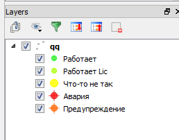
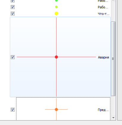
previous versions correctly cut the sign, and showed the same size. In this case, the display becomes not neat. In one of the beta versions of the sign displayed in full (horizontally and vertically), and this is bad. To illustrate the problem - try to strengthen it. Look at the new data. It would be logical to limit this symbolism, and does not reflect the whole as before. In the Layer Properties dialog box symbols displayed correctly. In this case, use the program becomes very uncomfortable.
#5
Updated by Alexander Novoselov over 10 years ago
- File qq.png added
#6
Updated by Giovanni Manghi over 10 years ago
- OS version deleted (
Ubuntu 14.04) - Affected QGIS version changed from 2.12.0 to master
- Operating System deleted (
Linux) - Target version set to Future Release - High Priority
- Priority changed from Normal to Severe/Regression
- Status changed from Feedback to Open
- Category changed from Symbology to Map Legend
- Subject changed from corrupt symbols in the Layers Panel to symbols not correctly clipped in map legend
- File 212_master.png added
- File 210.png added
- File 283.png added
#7
 Updated by Martin Dobias over 10 years ago
Hmm the question is what is a good fix for this :-)
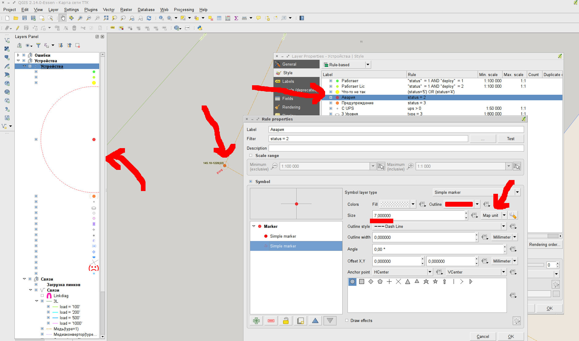
The variable size of legend icons has been introduced in 2.10 (and later updated to only change icon width to avoid vertically wide items). Without the dynamic icon size, bigger markers in legend would be impossible to distinguish. Some possibilities from the top of my head:- introduce a reasonable maximum icon width
- use dynamic icon width only for symbols with data-defined size
- something else?
Opinions are welcome...
#8
Updated by Alexander Novoselov over 10 years ago
Return the fixed value and the ability to specify the properties of the layer height and width icon.
#9
Updated by Alexander Novoselov over 10 years ago
#10
Updated by Alexander Novoselov over 10 years ago
- File qgis2.14.0.png added
Qgis 2.14.0
If map units are used, the legend changes, as in this video. It is necessary to roll back the changes in the legend. Or make the option "not to scale legend."
#11
 Updated by R. R. about 10 years ago
See also #14850
#12
Updated by Alexander Novoselov almost 10 years ago
Qgis 2.16.0 same error:
If map units are used, the legend changes, as in this video. It is necessary to roll back the changes in the legend. Or make the option "not to scale legend."
#13
Updated by R. R. over 9 years ago
- File 13779_geometry_generator.mp4 added
- File 13779_geometry_generator.zip added
Using a geometry generator style also causes weird symbols in the layers panel.
See also: #15860 (Geometry generator styling expands legend panel)
#14
Updated by Giovanni Manghi over 9 years ago
- Affected QGIS version changed from master to 2.18.4
- Target version changed from Future Release - High Priority to Version 3.0
This regression affects also the latest 2.18 release.
#15
Updated by Giovanni Manghi about 9 years ago
- Regression? set to Yes
#16
Updated by Giovanni Manghi about 9 years ago
- Priority changed from Severe/Regression to High
#17
Updated by Giovanni Manghi about 9 years ago
- Easy fix? set to No
#18
Updated by Giovanni Manghi over 7 years ago
- Resolution set to end of life
- Status changed from Open to Closed
End of life notice: QGIS 2.18 LTR
Source:
http://blog.qgis.org/2019/03/09/end-of-life-notice-qgis-2-18-ltr/
QGIS 3.4 has recently become our new Long Term Release (LTR) version. This is a major step in our history – a long term release version based on the massive updates, library upgrades and improvements that we carried out in the course of the 2.x to 3x upgrade cycle.
We strongly encourage all users who are currently using QGIS 2.18 LTR as their preferred QGIS release to migrate to QGIS 3.4. This new LTR version will receive regular bugfixes for at least one year. It also includes hundreds of new functions, usability improvements, bugfixes, and other goodies. See the relevant changelogs for a good sampling of all the new features that have gone into version 3.4
Most plugins have been either migrated or incorporated into the core QGIS code base.
We strongly discourage the continued use of QGIS 2.18 LTR as it is now officially unsupported, which means we’ll not provide any bug fix releases for it.
You should also note that we intend to close all bug tickets referring to the now obsolete LTR version. Original reporters will receive a notification of the ticket closure and are encouraged to check whether the issue persists in the new LTR, in which case they should reopen the ticket.
If you would like to better understand the QGIS release roadmap, check out our roadmap page! It outlines the schedule for upcoming releases and will help you plan your deployment of QGIS into an operational environment.
The development of QGIS 3.4 LTR has been made possible by the work of hundreds of volunteers, by the investments of companies, professionals, and administrations, and by continuous donations and financial support from many of you. We sincerely thank you all and encourage you to collaborate and support the project even more, for the long term improvement and sustainability of the QGIS project.