Feature request #9362

Export PDF layers from QGIS map composers
| Status: | Open | ||
|---|---|---|---|
| Priority: | Low | ||
| Assignee: | - | ||
| Category: | Map Composer/Printing | ||
| Pull Request or Patch supplied: | No | Resolution: | |
| Easy fix?: | No | Copied to github as #: | 17962 |
Description
As in the attached image.
PDF layers are formally known as Optional Content Groups.
"They represent a collection of graphic objects that can be made visible or invisible. Any graphic content of the PDF can be made optional, including page contents, XObjects, and annotations." Reference:
http://livedocs.adobe.com/acrobat_sdk/9.1/Acrobat9_1_HTMLHelp/API_References/Acrobat_API_Reference/PD_Layer/PDOCG.html
This feature would give the ability to open a PDF (generated from the QGIS composer) in Acrobat and enable/disable the visibility of layers.
Related issues
History
#1
 Updated by Jukka Rahkonen about 12 years ago
Feels the same as #8771 speaks about geopdf but it would be more safe to call it as geospatial pdf because GeoPDF is a trade mark.
#2
 Updated by Giovanni Manghi about 12 years ago
- Target version set to Future Release - Nice to have
To note that QGIS "can" already export (from the canvas, not the composer) as geopdf: the format is supported in gdal/ogr used by qgis, so it would be possible to export using the "save as..." vector function or the translate tool in the raster menu. But as far as I can see the "geopdf" format is not listed in the gui comboboxes.
#3
 Updated by Simon W about 11 years ago
Can we get a status on this or 8771?
#4
 Updated by Nyall Dawson about 11 years ago
Simon - nothing to report, as far as I'm aware no one is currently tackling this issue.
#5
 Updated by Asier Sarasua almost 11 years ago
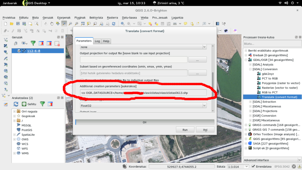
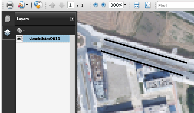
- File qgis_geopdf_2.png added
- File qgis_geopdf.png added
@Giovanni
As GDAL 1.10 supports GeoPDF, I successfully exported a PDF with layers (a raster layer and a polyline vector layer) from Processing inserting a OGR_DATASOURCE parameter in the "Additional creation parameters" box to add the vector layer. However, it only exports vectors without style. I have to investigate more into this1[2].
[1]http://www.gdal.org/frmt_pdf.html
[2]http://www.gdal.org/ogr_feature_style.html
#6
Updated by Giovanni Manghi almost 11 years ago
Asier Sarasua wrote:
@Giovanni
As GDAL 1.10 supports GeoPDF, I successfully exported a PDF with layers (a raster layer and a polyline vector layer) f
Hi,
yes this is expected beside the lack of options in QGIS gui.
The ticket is more about the possibility to export a map from the QGIS composer as geopdf.
#7
 Updated by Luca Delucchi almost 11 years ago
Hi,
I'm working on a plugin to create GeospatialPDF (not that real GeoPDF because is proprietary format) from raster and vector data loaded into QGIS, but not from QGIS composer.
I tried to investigate a little bit more about this possibility but I didn't find any good solution.
The plugin is close to be released (I hope in two/three weeks) and will have the following capabilities:
- export raster and styled vector (probably all the three QGIS symbol style)
- most of the GeospatialPDF "Creation Options" [0] are supported
- support for legend/scalebar/images and choose their position in the GeospatialPDF.
#10
 Updated by James Wilson over 10 years ago
If you want to make a Georeferenced PDF for Avenza:
Set up your print composer, and export it as a georeferenced image
(https://docs.qgis.org/2.6/en/docs/user_manual/print_composer/print_composer.html#creating-output)
Bring this back into your project as use Raster > Conversion > Translate
to export it as a georeferenced PDF
#11
 Updated by amedeo fadini over 9 years ago
I'm also interested in this feature: the planned use case is to distribute a PDF map or atlas in PDF format and give to the final user the chance to print the whole map or only the layers of interest.
#12
Updated by Giovanni Manghi almost 9 years ago
- Easy fix? set to No