Bug report #4462

When drawing a new polygon it inverts existing parts of the polygon
| Status: | Closed | ||
|---|---|---|---|
| Priority: | Normal | ||
| Assignee: | - | ||
| Category: | Digitising | ||
| Affected QGIS version: | master | Regression?: | No |
| Operating System: | Easy fix?: | No | |
| Pull Request or Patch supplied: | No | Resolution: | wontfix |
| Crashes QGIS or corrupts data: | No | Copied to github as #: | 14389 |
Description
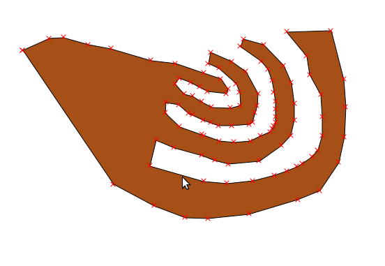
When you draw a new polygon it inverts already drawn parts of the polygon back to the layer underneath. I would have expected an doubling in colour or half the transparency of the red layer of the polygon. The encircled area in the attached image should be a darker colour rather than inverted.
History
#1
 Updated by Giovanni Manghi over 14 years ago
can't see any attached image. It would be useful to understand better what do you mean.
#2
 Updated by Gerhardus Geldenhuis over 14 years ago
- File Screenshot01.png added
Apologies must have missed off the image. Hope it helps to clarify what I mean.
#3
Updated by Giovanni Manghi over 14 years ago
- Category changed from GUI to Digitising
- Status changed from Open to Feedback
The overlapped part it hasn't a "reverted color" it is (it becomes) a hole. The simple features model does not allow to draw such geometries (self-overlapping), and QGIS let you know by marking those two nodes with a green "X".
I agree with others that eventually allow to draw such wrong geometries it is not right. An option that can be eventually be discussed/added could be the one to make qgis refuse to add invalid geometries.
#4
Updated by Gerhardus Geldenhuis over 14 years ago
I should have been clearer. The screenshot is in mid-edit so the edit is not finished. I would certainly agree that you should not be allowed to make "wrong" geometries. What I am suggesting is that when you are digitizing a complex shape it would be useful when you overlap the existing polygon to not become a "hole" but rather double in colour density. That would be more intuitive. I am not suggesting the ability to draw wrong shapes but suggesting a more intuitive way for the polygon "shadow" or whatever the correct terminology is to behave in a more real life physical way. I equate the to folding a piece of semi transparent film over it self, it will darken in colour every time you fold it.
#5
Updated by Giovanni Manghi over 14 years ago
Gerhardus Geldenhuis wrote:
I should have been clearer. The screenshot is in mid-edit so the edit is not finished. I would certainly agree that you should not be allowed to make "wrong" geometries. What I am suggesting is that when you are digitizing a complex shape it would be useful when you overlap the existing polygon to not become a "hole" but rather double in colour density. That would be more intuitive. I am not suggesting the ability to draw wrong shapes but suggesting a more intuitive way for the polygon "shadow" or whatever the correct terminology is to behave in a more real life physical way. I equate the to folding a piece of semi transparent film over it self, it will darken in colour every time you fold it.
ok, now is clearer, but the doubt remains, why do so if at the end that area will become an hole anyway?
#6
Updated by Gerhardus Geldenhuis over 14 years ago
- File Screenshot-1.png added
- File Screenshot.png added
I will explain with an example the first image is midway through editing and the second image is the result. It is per illustration only. However I realize while creating these images that there is a logic problem... I don't think what I am asking is doable anyway... I am expecting the computer to know what I want to do and it can't possibly do that...
#7
Updated by Giovanni Manghi over 14 years ago
Gerhardus Geldenhuis wrote:
I will explain with an example the first image is midway through editing and the second image is the result. It is per illustration only. However I realize while creating these images that there is a logic problem... I don't think what I am asking is doable anyway... I am expecting the computer to know what I want to do and it can't possibly do that...
I understand your point, but as you say, what the program can do for it?
Any evidence that other sw packages (gvsig, udig, kosmo, etc.) do work in a way that can be considered better than the qgis way?
#8
Updated by Gerhardus Geldenhuis over 14 years ago
I have not used any of the other software packages mentioned so would unfortunetly have no idea. On the whole so far I have really liked the experience in QGIS
#9
Updated by Giovanni Manghi over 14 years ago
Gerhardus Geldenhuis wrote:
I have not used any of the other software packages mentioned so would unfortunetly have no idea. On the whole so far I have really liked the experience in QGIS
at the next developer meeting I will try to have a chat with the devs about this matters (in general how overlapping polygons are handled).
#10
Updated by Giovanni Manghi over 14 years ago
- Target version set to Version 1.7.4
#11
 Updated by Paolo Cavallini about 14 years ago
- Target version changed from Version 1.7.4 to Version 1.8.0
- Affected QGIS version set to master
- Crashes QGIS or corrupts data set to No
#12
Updated by Paolo Cavallini over 13 years ago
- Target version changed from Version 1.8.0 to Version 2.0.0
#13
 Updated by Jürgen Fischer almost 12 years ago
- Target version changed from Version 2.0.0 to Future Release - Lower Priority
#14
Updated by Giovanni Manghi over 11 years ago
- Status changed from Feedback to Closed
- Resolution set to wontfix