Feature request #17219

Better description of bands
| Status: | Closed | ||
|---|---|---|---|
| Priority: | Normal | ||
| Assignee: | - | ||
| Category: | GUI | ||
| Pull Request or Patch supplied: | No | Resolution: | fixed/implemented |
| Easy fix?: | No | Copied to github as #: | 25118 |
Description
Some multiband fornmat (I have checked especialli GRIB) have a description in the metadata for the meaning of each band (e.g. wind speed 10 m above ground). In the layer properties > Style, only the band numbers are listed (band 1 etc.).
This makes styling very difficult. It would seem reasonable to add the metadata to the band number, e.g.:
Band 1 (wind speed 10 m above ground)
Related issues
History
#1
 Updated by Nyall Dawson over 8 years ago
- Status changed from Open to Feedback
Can you share one of these files?
#2
 Updated by Paolo Cavallini over 8 years ago
http://www.faunalia.eu/~paolo/grib.zip
Thanks.
BTW: I do not know whether this is a general issue, but the projection for this particular file (EPSG:4326) is not correctly interpreted.
#3
Updated by Paolo Cavallini over 8 years ago
Misinterpretation of EPSG code confirmed with other GRIBs from other sources.
#4
 Updated by Giovanni Manghi over 8 years ago
- File Screenshot_20180116_144439.png added
Paolo Cavallini wrote:
Misinterpretation of EPSG code confirmed with other GRIBs from other sources.
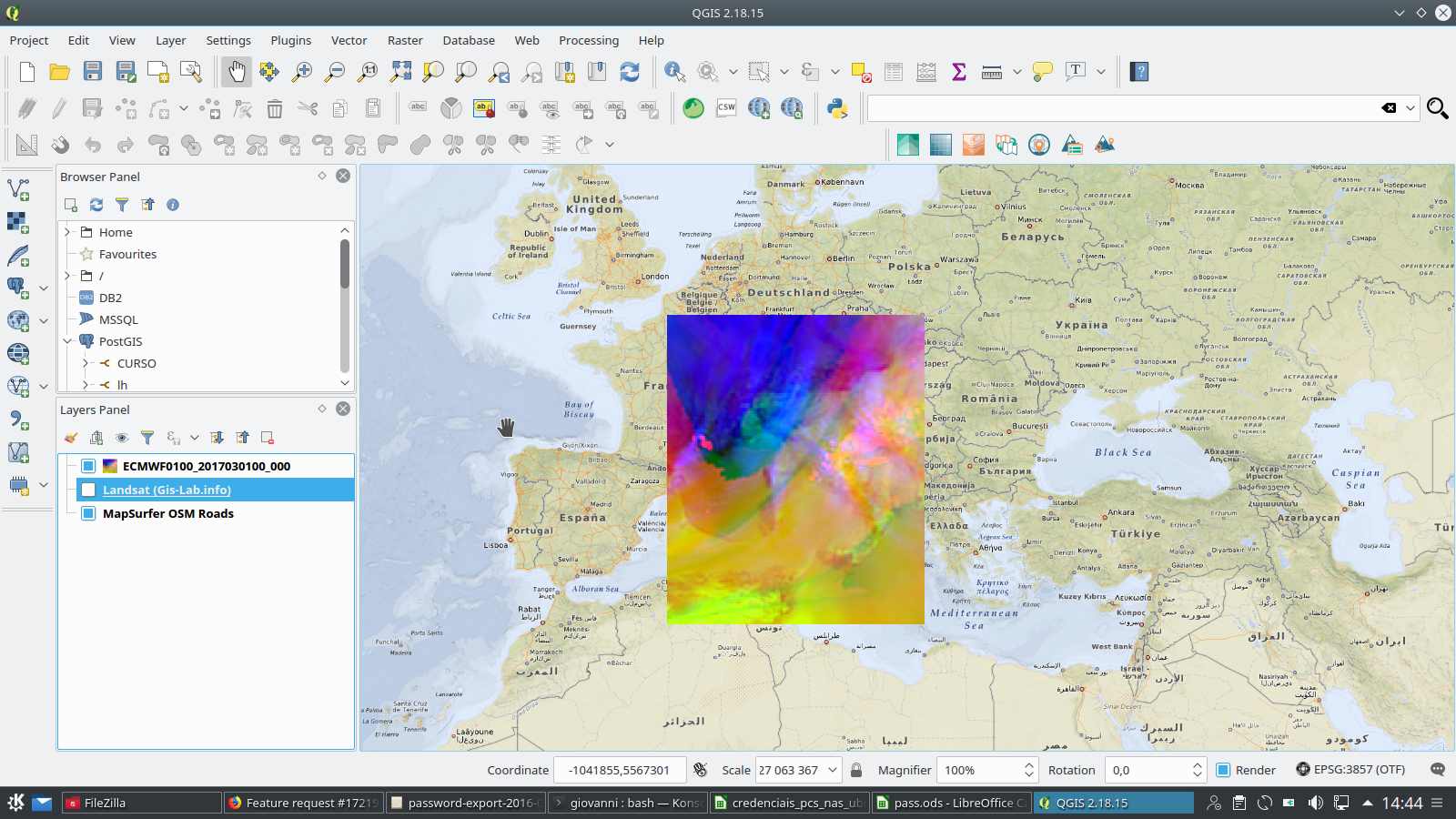
here on 2.18.* and gdal 2.2.2:
both gdal (and qgis) read a custom CRS (+proj=longlat +a=6367470 +b=6367470 +no_defs) but this definitely seems to reproject to the right place, see attached image.
#5
Updated by Paolo Cavallini over 8 years ago
Confirmed, thanks for checking. As mentioned in mailing list, GRIBS dowloaded and correctly visualized in ZyGrib are not projected correctly, see http://www.faunalia.eu/~paolo/grib2.bz2
This is outside the scope of the current ticket however.
#6
Updated by Giovanni Manghi over 8 years ago
Paolo Cavallini wrote:
Confirmed, thanks for checking. As mentioned in mailing list, GRIBS dowloaded and correctly visualized in ZyGrib are not projected correctly, see http://www.faunalia.eu/~paolo/grib2.bz2
This is outside the scope of the current ticket however.
gdalinfo reports messages like
Band 1206 Block=109x1 Type=Float64, ColorInterp=Undefined
Description = 0[-] SFC (Ground or water surface)
Un-handled possible ensemble section center 58 subcenter 0
Warning 1: Band 1206 of GRIB dataset is 130x99, while the first band and dataset is 109x89. Georeferencing of band 1206 may be incorrect, and data access may be incomplete.
NoData Value=9999
Metadata:
GRIB_COMMENT=undefined [-]
GRIB_ELEMENT=var155
GRIB_FORECAST_SECONDS=345600 sec
GRIB_REF_TIME= 1515456000 sec UTC
GRIB_SHORT_NAME=0-SFC
GRIB_UNIT=[-]
GRIB_VALID_TIME= 1515801600 sec UTC
so I would say it is GDAL or zygrib problem.
#7
Updated by Nyall Dawson over 8 years ago
- Resolution set to up/downstream
#8
Updated by Paolo Cavallini over 8 years ago
- Resolution deleted (
up/downstream)
We are mixing up things here, my fault.
1. the projection issue: unclear whether this is due to QGIS misinterpreting EPSG:4326 or Zygrib/GDAL providing invalid projection; I will do more research
2. wrong extent: brilliantly clarified by Giovanni, thanks
3. description of bands: remains valid, it' a QGIS GUI issue, possibly not too difficult.
Thanks all for feedback.
#9
Updated by Paolo Cavallini over 8 years ago
For reference: http://www.zygrib.org/forum/viewtopic.php?f=3&t=1069
#10
Updated by Paolo Cavallini over 8 years ago
Projection issue seems due to Zygrib, in any case not to QGIS:
Driver: GRIB/GRIdded Binary (.grb)
Files: ECMWF0100_2017030100_000.grb
Size is 181, 161
Coordinate System is:
GEOGCS["Coordinate System imported from GRIB file",
DATUM["unknown",
SPHEROID["Sphere",6367470,0]],
PRIMEM["Greenwich",0],
UNIT["degree",0.0174532925199433]]
Origin = (1.950000000000000,50.049999999999997)
Pixel Size = (0.100000000000000,-0.100000000000000)
Corner Coordinates:
Upper Left ( 1.9500000, 50.0500000) ( 1d57' 0.00"E, 50d 3' 0.00"N)
Lower Left ( 1.9500000, 33.9500000) ( 1d57' 0.00"E, 33d57' 0.00"N)
Upper Right ( 20.0500000, 50.0500000) ( 20d 3' 0.00"E, 50d 3' 0.00"N)
Lower Right ( 20.0500000, 33.9500000) ( 20d 3' 0.00"E, 33d57' 0.00"N)
Center ( 11.0000000, 42.0000000) ( 11d 0' 0.00"E, 42d 0' 0.00"N)
#11
Updated by Paolo Cavallini over 8 years ago
So we can go back to the original issue: showing in the name of bands also their description, as reported by GDAL, to make it easier for users to interpret and symbolize data.
#12
Updated by Paolo Cavallini about 8 years ago
- Status changed from Feedback to Open
#13
 Updated by Saber Razmjooei over 7 years ago
- Related to Bug report #19586: Problem reading grib file added
#14
Updated by Saber Razmjooei over 7 years ago
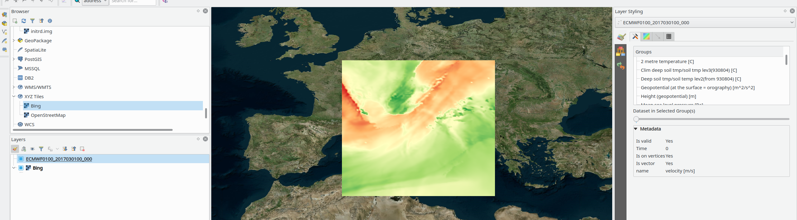
It works fine in QGIS master when loading the layer as mesh:
https://issues.qgis.org/issues/19586
https://issues.qgis.org/attachments/download/13105/grib.png
#15
Updated by Giovanni Manghi over 7 years ago
- Status changed from Open to Feedback
#16
Updated by Paolo Cavallini over 7 years ago
- Status changed from Feedback to Closed
- Resolution set to fixed/implemented
Confirmed, thanks.