Bug report #15752

Degradation of rendering performances in MSSQL provider
| Status: | Closed | ||
|---|---|---|---|
| Priority: | High | ||
| Assignee: | |||
| Category: | Data Provider/MSSQL | ||
| Affected QGIS version: | 2.18.16 | Regression?: | Yes |
| Operating System: | Windows | Easy fix?: | No |
| Pull Request or Patch supplied: | No | Resolution: | |
| Crashes QGIS or corrupts data: | No | Copied to github as #: | 23674 |
Description
All version since 2.14.x raised the render time compared to 2.8.x:

I used the same virtual machine (install, test and used snapshot prior install) and the same data source.
I doesn't matter the source of the data, MSSQL, Shapefile, Postgres and the bigger the geometry quantity, bigger the render difference.
I looked for something in the settings to revert It without compromising the image quality but I couldn't find anything.
Is this a problem or It is just the way QGIS will work for now on?
Related issues
Associated revisions
Speed up point layer rendering - don't calculate unused label obstacles
Cuts render time by ~60%. Fix #15752.
Optimise QgsAbstractGeometry
Make nCoordinates virtual, and provide shortcuts for some
geometry types. The base method which calls coordinateSequence()
is quite slow in certain circumstances.
Speeds up rendering point layers by ~25%, also likely to
speed up lots of geometry heavy operations throughout QGIS
Refs #15752
Use QgsExpressionContextScope::addVariable instead of setVariable
...where appropriate (ie, read-only, non user set variables).
It's much faster as it doesn't need to check whether the
variable already exists.
Results in ~10% improvement in rendering speed. Refs #15752.
Speed up point layer rendering - don't calculate unused label obstacles
Cuts render time by ~60%. Fix #15752.
(cherry-picked from 5798a82c8011ea7f44a1ed1d55ef0719786e8056)
Optimise QgsAbstractGeometry
Make nCoordinates virtual, and provide shortcuts for some
geometry types. The base method which calls coordinateSequence()
is quite slow in certain circumstances.
Speeds up rendering point layers by ~25%, also likely to
speed up lots of geometry heavy operations throughout QGIS
Refs #15752
(cherry-picked from 49432a84683e99bdc2592e7ae808e81fa3bc40cd)
Use QgsExpressionContextScope::addVariable instead of setVariable
...where appropriate (ie, read-only, non user set variables).
It's much faster as it doesn't need to check whether the
variable already exists.
Results in ~10% improvement in rendering speed. Refs #15752.
(cherry-picked from 85897885445c7383938ac89318d12a7d37024bb4)
[mssql] Use Filter instead of STIntersects to improve query performance
...and refine validity test from 57dc3c7
Using Filter is more performant since it does a bounding box only
check when an appropriate spatial index is available. This matches
the behavior with other providers, where the provider filter only
does a bounding box check and callers must perform the actual
intersection check if required.
While Filter also avoids SQL server closing the iterator upon
encountering invalid geometries, we can't rely on this because SQL
server will transparently fall back to STIntersects if it
decides there's no suitable spatial indexes available, and then
throw an exception on invalid geometries. So we still require
the STISValid check when using Filter.
The extent calculation from 57dc3c7 has been refined to
avoid the very expensive STMakeValid call. Instead we use a (ugly!)
workaround to skip invalid geometries using STIsValid only
inside the min/max x/y aggregates. Note that we can't just
dump a WHERE STIsValid clause in to the statement because SQL
server still throws the exception. Gotta love it!
[mssql][needs-docs] Add connection setting to ignore invalid geometry handling
Sets whether the connection should skip all handling of records with
invalid geometry, which are slow and costly.
This speeds up the provider, however, if any invalid geometries
are present in a table then the result is unpredictable and may
include missing records. Only check this option if you are certain
that all geometries present in the database are valid, and any newly
added geometries or tables will also be valid!
Why would we want this? Well, SQL Server invalid geometry handling
is AWEFUL. A seriously lame, data mangling and corrupting
piece of s***. Use Postgres instead. But if you can't, then you
can at least choose to use your layers at full speed, if you
can take the responsibility that a SINGLE invalid geometry
hiding somewhere in the table will result in a whole bunch
of missing (valid) features.
SQL server is at fault here, not us. There's nothing we (or
GDAL, or MapServer, or GeoServer, or anyone else) can do
to fix this.
Suffice to say, this option is off by default, as we're better
to have a slow provider which actually shows all features.
Fixes #15752
Rant over
[mssql] Forward port more of 62af54e
But avoid the inexact Filter test when we are doing an
exact intersection request
Refs #15752
History
#1
 Updated by Nyall Dawson over 9 years ago
What renderer/symbol style are you using?
#2
Updated by Nyall Dawson over 9 years ago
- Status changed from Open to Feedback
#3
 Updated by Andre Jesus over 9 years ago
What renderer/symbol style are you using?
I'm using default QGIS style.
The same occurs using WFS:
ly1 WFS/linestring
2.8.x = 16 ms
2.14.x+ = 517 ms
ly2 WFS/polygon
2.8.x = 17 ms
2.14.x+ = 219 ms
ly3 WFS/point
2.8.x = 15 ms
2.14.x+ = 647 ms
Always using the same bookmark and data.
I have 20 other machines with the same results.
#4
Updated by Andre Jesus over 9 years ago
Sorry, I don't know if my answer was clear. I'm using default Single Symbol style without any change.
#5
Updated by Nyall Dawson over 9 years ago
- Status changed from Feedback to Closed
Fixed in changeset 5798a82c8011ea7f44a1ed1d55ef0719786e8056.
#6
 Updated by Steve Lowman over 9 years ago
- Target version changed from Version 2.18 to Version 2.14
- Status changed from Closed to Reopened
Has this been fixed in 2.18 but not 2.14? I just changed the Target version from 2.18 to 2.14 - hope that's ok.
We use a large feature set of UK Ordnance Survey MasterMap (OSMM) Topographic Layer in shapefiles in the LTR (currently 2.14.8), about 100K ha area. The data are stored on a local server in the same building, so bandwidth is not a big part of this issue. Topographic Line is geometrically the most complex OSMM feature set, and this has a noticeable lag in rendering with this large feature set. The lag is > 2 secs at 1:20K scale, slower at smaller scales (larger visible extent), quicker at larger scales (smaller visible extent).
Our workaround is to break up the feature set into five smaller chunks, and then the lag is a lot less at any given scale. This is a pain, because we have to divide it up every time we get an updated OSMM feature set.
When this first started happening was the first release of 2.14, and I assumed it was probably caused by the more complex geometry engine that allows curved lines.
#7
Updated by Nyall Dawson over 9 years ago
- Status changed from Reopened to Closed
These fixes are included in 2.14.9 and 2.18.1. Try with those versions. Otherwise this is likely a different issue and a new report needs to be opened.
Fyi, new geoemtry was introduced in 2.10
#8
Updated by Andre Jesus over 9 years ago
- Target version changed from Version 2.14 to Version 2.18
- Status changed from Closed to Reopened
I did the compare again using QGIS 2.18.1

I can see some improvements rendering polygons, but not on points and linestrings.
ps.: Render times are rounded.
#9
Updated by Nyall Dawson over 9 years ago
Hmm... that's quite odd. You should definitely see an improvement in 2.18.1.
Are you using labels in these tests?
#10
Updated by Andre Jesus over 9 years ago
The last time I tested It I did a dirt install.
To cross It out I set up a new VM with Windows 7 32 bits, made a snapshot before installing any software.
I didn't tweaked any setting in QGIS but enable Debug: Map Canvas Refresh
Here the new results:

Yes, I was using simple style without labels or any change to default QGIS style.

#11
 Updated by Giovanni Manghi about 9 years ago
- Category set to Map Canvas
#12
Updated by Andre Jesus about 9 years ago
Latest update: Using 2.18.4
Render time seems to keep rising every update.
Every relatively big layer I have now became a slug with version 2.18.4.
To me, It looks like QGIS doesn't pass the bounding box when querying data from the database, bringing all data all the time. If I query 1000 or all 170.000 features, the rendering time is about the same. While, if I do the same using PostgreSQL I jump from 42 ms (1.000 feature count) to 2400 ms (173.000 features)
173.000 polygon layer, average render time (3 runs):

1:125.000 (173.000 features)
Postgres: 2383 ms
Mssql: 20151 ms

1:4.000 (1.300 features)
Postgres: 140 ms
Mssql: 13756 ms
As shown above, PostgreSQl had a 94% render time reduction and MSSQL only 31%, that considering a 99% features displayed reduction.
#13
Updated by Giovanni Manghi about 9 years ago
- Affected QGIS version changed from 2.18.0 to 2.18.4
#14
Updated by Andre Jesus about 9 years ago
I did some more testing...
Using the same map, layers and zoom levels.
Feature list and count:
Zoom: 1:400.000

Zoom: 1:7.000

Wider zoom levels:
2.8.9 > 2.14.12 = + 41% render time
2.14.12 > 2.18.4 = + 290% render time
Smaller zoom levels:
2.8.9 > 2.14.12 = + 7% render time
2.14.12 > 2.18.4 = + 4604% render time
I know MSSQL data provider is not the focus in development but it's impossible to work with It in 2.18.4.
#15
Updated by Giovanni Manghi about 9 years ago
I know MSSQL data provider is not the focus in development but it's impossible to work with It in 2.18.4.
please raise this matter on the users and/or developers mailing lists.
#16
Updated by Andre Jesus about 9 years ago
Giovanni Manghi wrote:
I know MSSQL data provider is not the focus in development but it's impossible to work with It in 2.18.4.
please raise this matter on the users and/or developers mailing lists.
Ok.
Each one would be more suitable: User or Developers mailing list? I've never joined one before.
I'm no developer but I'd like to contribute as I can.
#17
Updated by Giovanni Manghi about 9 years ago
Andre Jesus wrote:
Giovanni Manghi wrote:
I know MSSQL data provider is not the focus in development but it's impossible to work with It in 2.18.4.
please raise this matter on the users and/or developers mailing lists.
Ok.
Each one would be more suitable: User or Developers mailing list? I've never joined one before.
I'm no developer but I'd like to contribute as I can.
the developers one (which is not followed just by developers) is the right place for me: there you find the people that may help understand because of this regression.
#18
Updated by Giovanni Manghi about 9 years ago
Andre Jesus wrote:
Giovanni Manghi wrote:
I know MSSQL data provider is not the focus in development but it's impossible to work with It in 2.18.4.
please raise this matter on the users and/or developers mailing lists.
Ok.
Each one would be more suitable: User or Developers mailing list? I've never joined one before.
I'm no developer but I'd like to contribute as I can.
One question: have you any idea if this also affects other providers, like PostGIS?
#19
Updated by Andre Jesus about 9 years ago
Giovanni Manghi wrote:
One question: have you any idea if this also affects other providers, like PostGIS?
It doesn't.
Running the same bench test using Shapefiles or PostGIS both gives me ~1500 ms
#20
Updated by Andre Jesus about 9 years ago
Just checking how performance went with other data providers over the 3 versions:
Using the same map but with a different zoom level (1:177.000)
While doing the benchmark, QGIS force closed 5 times using 2.18.4 and 2 using 2.14.12 when refreshing MSSQL layers. None with the other providers.
2.8.9 is by far the fastest, but It's understandable by the amount of features added to QGIS It would slow It down.
#21
Updated by Giovanni Manghi about 9 years ago
2.8.9 is by far the fastest, but It's understandable by the amount of features added to QGIS It would slow It down.
well... I don't think that we should assume that is all ok also with other providers... it seems to me that is pretty bad also for postgis and shapefiles.
I noticed a very noticeable degradation of performances in QGIS3 master compared to 2.18.4 and reported it, hopefully this will be sorted and fixed for all providers.
#22
Updated by Andre Jesus about 9 years ago
It's not related how QGIS request data from the database as all version uses the same intersects method with the same limit.
And that kills my theory he may be request all geometries all the time.
SELECT [OBJECTID],[GEOMETRY]FROM [dbo].[LIGACOES] where [GEOMETRY].STIsValid() = 1 AND [GEOMETRY].STIntersects([geometry]::STGeomFromText('POLYGON((589164.07187500002328306 8262041.58740026596933603, 614628.80312499997671694 8262041.58740026596933603, 614628.80312499997671694 8286332.41259973403066397, 589164.07187500002328306 8286332.41259973403066397, 589164.07187500002328306 8262041.58740026596933603))',29191)) = 1
But checking SQL Server Profiler I noticed different values in CPU cycles and duration, even they all using the exactly same query, the values ares persistent.
Again a 3 times avg:

It could be a good lead to find out what went wrong, but my knowledge ends here.
#23
Updated by Andre Jesus almost 9 years ago
Update versions: 2.14.13 and 2.18.5
Loading a 5 layers project (feature count: 201.528 points, 36.521 linestrings, 24.957 linestrings, 9.231 polygons, 9.875 polygons), 5x avg canvas refresh time, roughly rounded values:
2.14.13
3500 ms mssql
1500 ms postgis
2.18.5
19443 ms mssql
1400 ms postgis
2.14.13 seems to have stabilized the performance using MSSQL. On the other hand 2.18.5 is getting worse, jumping from ~15.000 ms to ~20.000 ms (25% increase)
Edit: 2.14.13 feels faster now
#24
Updated by Nyall Dawson almost 9 years ago
- Status changed from Reopened to Feedback
To summarise - I believe that when disregarding the comparisons between release and debug builds the issue is reduced to a regression in the mssql provider alone. Is this correct?
#25
Updated by Andre Jesus almost 9 years ago
None of the tests I did here were using debug versions (by that time I didn't even know I was able to install and use them).
I think the performance degradation does impact all providers, just not as much as It impacts MSSQL (see note #15752-20).
#26
Updated by Giovanni Manghi almost 9 years ago
- Status changed from Feedback to Open
I think that note 20 says a lot. Many thanks to the reported for this very detailed analysis!
#27
Updated by Giovanni Manghi almost 9 years ago
- Regression? set to Yes
#28
Updated by Giovanni Manghi almost 9 years ago
- Priority changed from Severe/Regression to High
#29
Updated by Giovanni Manghi almost 9 years ago
- Easy fix? set to No
#30
Updated by Andre Jesus almost 9 years ago
Update: 2.14.14 LTS / 2.18.7

Using the same layers used to benchmark on note 20.
Testing the first run and 3 consecutive canvas refreshes using 1:255.000 and 1:7.000 scales. Using default OSGeo installation, no extra plugin installed.
I had an OS problem and I lost 2.8.9 installer, that's why there is no results for it.
MSSQL performance is still terrible, but PostGIS had a nice improvement.
#32
 Updated by Jürgen Fischer almost 9 years ago
- Related to Bug report #16577: Extremely slower time to open attribute table in 2.18.7 compared to 2.14.14 added
#33
Updated by Giovanni Manghi almost 9 years ago
#34
Updated by Nyall Dawson almost 9 years ago
- Status changed from Open to Closed
- % Done changed from 0 to 100
Applied in changeset qgis|5798a82c8011ea7f44a1ed1d55ef0719786e8056.
#35
Updated by Giovanni Manghi almost 9 years ago
Nyall Dawson wrote:
Applied in changeset qgis|5798a82c8011ea7f44a1ed1d55ef0719786e8056.
Dear Andre Jesus would you mind see if the above commit improves things as expected? thanks!
#36
Updated by Giovanni Manghi almost 9 years ago
Giovanni Manghi wrote:
Nyall Dawson wrote:
Applied in changeset qgis|5798a82c8011ea7f44a1ed1d55ef0719786e8056.
Dear Andre Jesus would you mind see if the above commit improves things as expected? thanks!
see also https://drive.google.com/file/d/0B8VD1V_leaeWNmpaOFNxZGxicVU/view?usp=sharing
#37
Updated by Giovanni Manghi almost 9 years ago
- Subject changed from Slow render time to Degradation of rendering performances in MSSQL provider
- Status changed from Closed to Open
#38
Updated by Giovanni Manghi almost 9 years ago
reopened as requested here
https://lists.osgeo.org/pipermail/qgis-psc/2017-May/005319.html
#39
Updated by Nyall Dawson almost 9 years ago
- Status changed from Open to Closed
Applied in changeset qgis|62af54ecb2666d0bde0f7af102d663ded5cda97d.
#40
Updated by Andre Jesus almost 9 years ago
Giovanni Manghi wrote:
Dear Andre Jesus would you mind see if the above commit improves things as expected? thanks!
Sorry I was on vacation.
Are these changes applied to the final Windows build?
Comparing the numbers alone I don't see improvements, but in the daily usage I find 2.14.15 LTR to be good enough.
On the other hand, 2.18.x is a totally skip.
I compared It using #note-14 because I could use the same layers/scales.
Using QGIS 2.18.9 64 bits, Windows Standalone installer. Projected layers.
Using QGIS 2.14.15 LTR 64 bits, Windows Standalone installer. Projected layers.
#41
Updated by Giovanni Manghi almost 9 years ago
you probably have to try qgis master or 2.18.9 nightly or wait the next 2.18 build (but I'm not sure the fix has been backported)
Andre Jesus wrote:
Giovanni Manghi wrote:
Dear Andre Jesus would you mind see if the above commit improves things as expected? thanks!
Sorry I was on vacation.
Are these changes applied to the final Windows build?
Comparing the numbers alone I don't see improvements, but in the daily usage I find 2.14.15 LTR to be good enough.
On the other hand, 2.18.x is a totally skip.I compared It using #note-14 because I could use the same layers/scales.
Using QGIS 2.18.9 64 bits, Windows Standalone installer. Projected layers.
Using QGIS 2.14.15 LTR 64 bits, Windows Standalone installer. Projected layers.
#42
Updated by Nyall Dawson almost 9 years ago
These changes aren't in master yet, or any of the released 2.18 versions. Can you please install the qgis-rel-dev version using osgeo4w add test using that?
#43
Updated by Andre Jesus almost 9 years ago
Nyall Dawson wrote:
These changes aren't in master yet, or any of the released 2.18 versions. Can you please install the qgis-rel-dev version using osgeo4w add test using that?
Aren't those versions debug-enabled? I remember from another issue the comparison between final and dev build irrelevant as the performance is degraded because of the debug flags.
I installed QGIS-OSGeo4W-2.99.0-23-Setup-x86_64.exe (05-Jun-2017 06:29 463M) from the weekly builds (http://qgis.org/downloads/weekly/).
The results are close or worse than the QGIS 2.18.9 final build times.
#44
Updated by Nyall Dawson almost 9 years ago
You could compare it against qgis-ltr-dev. That's a debug enabled 2.14 release.
What's the commit number from the about screen in the weekly you are running? I suspect its probably from before the recent changes.
#45
Updated by Nyall Dawson almost 9 years ago
Actually I just realised you mentioned 2.99. The fixes aren't in master builds yet. You'll need to test qgis-rel-dev from osgeo4w, that's the only pre-built version with these changes available.
#46
Updated by Andre Jesus almost 9 years ago

Even with the debug flags qgis-rel-dev was faster than the 2.18 final release. I guess we can expect the same performance between 2.14.x and 2.18.x for now on. Thank you, Nyall!
#47
Updated by Nyall Dawson almost 9 years ago
I'm confused - did you attach the wrong table above? It looks like it's still slower to me?
#48
Updated by Andre Jesus almost 9 years ago
Nyall Dawson wrote:
I'm confused - did you attach the wrong table above? It looks like it's still slower to me?
Comparing 2.18.x vs 2.14.x both dev versions, 2.18 is slower than 2.14.
But when comparing 2.18.x dev to 2.18.x final, even with the debug flags the dev is faster than the final version.
I confess I got a little excited there and maybe the 2.18 still doesn't have the same performance as 2.14 has, but it's a great improvement, the render time may drop another 30-40% with debug off...
Just out of curiosity, I installed QGIS 2.8.9-2 x86 again, which is the fastest version so far, to see how far off the 2.14.x is from it. It's pretty close, 2.8.9 is still the fastest but only by ~8%.
#49
Updated by Nyall Dawson almost 9 years ago
Ok - let's do some more tests. I'm curious if it's the added IsValid check which is causing these remaining regressions (you can see discussion about why this check is required at https://github.com/qgis/QGIS/pull/4642)
Can you run these benchtests directly on your sql server to get the timing for the query on the server alone (no qgis involved):
- select everything from the layers , no where clause
- select everything from the layers, with an 'WHERE geom.STIsValid() = 1' clause
- select from the layers using a restricted bounding box check (eg something like 'WHERE geom.Filter(Polygon::STGeomFromText('POLYGON)',4326)) = 1', but with the correct crs/etc)
- same as above, but with a 'WHERE geom.STIsValid() = 1 AND geom.Filter....etc)
I'd like to see how much of an impact the validity checks are adding on your query times. It would be good to narrow down the regression to the presence of the validity check and not other factors so we can refine further investigation.
#50
Updated by Andre Jesus almost 9 years ago
results: https://drive.google.com/open?id=11GY4OxK0Xy2HULLrJ1xB4MuLAZcpF-MP7ADUKLiHBRg
tl;dr
Using IsValid has a huge impact in performance in points and polygons, linestrings also has a big slow down but not as much.
What was interesting to see was how big the difference when using both bbox filter and isValid together is. It basically sums bbox filter + isValid cpu times and doubles it!
just another 2 cents: geom.filter is slightly better than the geom.STIntersects it's currently used (57dc3c7eff2337411c163222a4e5b7562fffd457)
#51
Updated by Andre Jesus over 8 years ago
Updated results:

#52
Updated by Andre Jesus over 8 years ago
Sorry to keep bothering about it, but I don't think it's closed as the current 2.18.x versions are still 6x slower than the 2.14.x versions.
And the 2.18.x becoming the next LTR version it really worries me.
#53
Updated by Giovanni Manghi over 8 years ago
- Status changed from Closed to Feedback
Andre Jesus wrote:
Sorry to keep bothering about it, but I don't think it's closed as the current 2.18.x versions are still 6x slower then the 2.14.x versions.
And the 2.18.x becoming the next LTR version it really worries me.
I assume that have you tried the latest available 2.18, correct?
#54
Updated by Andre Jesus over 8 years ago
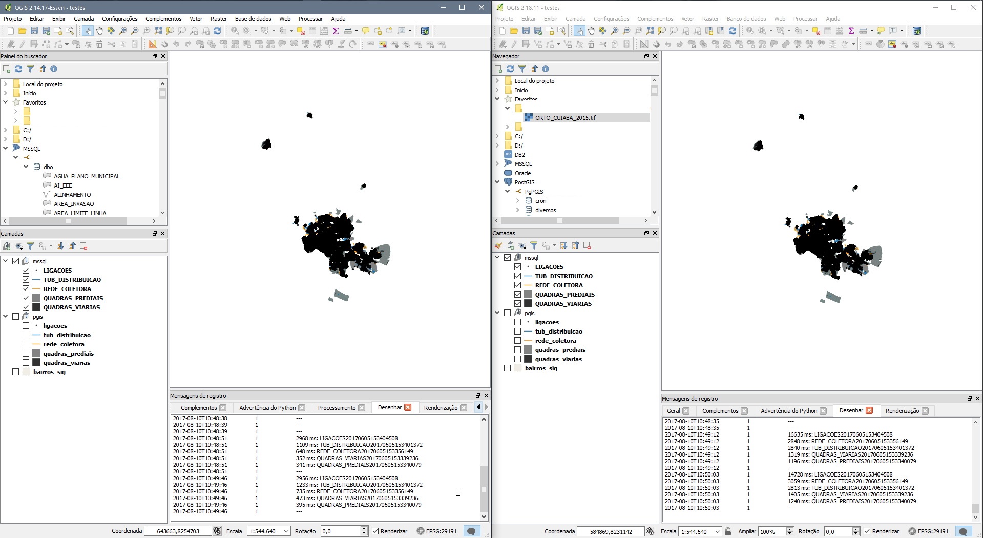
- File 2.18.11.jpg added
Giovanni Manghi wrote:
I assume that have you tried the latest available 2.18, correct?
I keep testing every version for improvements.
#55
Updated by Giovanni Manghi over 8 years ago
- Affected QGIS version changed from 2.18.4 to 2.18.11
- Status changed from Feedback to Open
#56
Updated by Andre Jesus over 8 years ago
New results: 2.18.13, 2.14.19, 2.8.9

#57
 Updated by Stijn Van der Linden about 8 years ago
Hello,
Is this still being looked at? With the upcoming release of QGIS 3.0, the LTR version will become 2.18.x instead of 2.14.x. I just checked 2.18.16 versus 2.14.22 and the problem persists. Loading a MSSQL layer in 2.18.16 takes several minutes compared to the same layer in 2.14.22, which is loaded in a matter of seconds.
This makes 2.18.16 unusable unless I don't use SQL sources (which is notreally an option).
#58
Updated by Giovanni Manghi about 8 years ago
- Affected QGIS version changed from 2.18.11 to 2.18.16
#59
Updated by Nyall Dawson about 8 years ago
I've looked into this issue in depth and there's no easy answers here.
We have to choose between:
1. Full performance - yet undefined behavior whenever a layer contains invalid geometries. (Undefined behavior here will mean missing features from the mssql table in the QGIS layer. Not just those with invalid geometries, but any feature present AFTER an invalid geometry is encountered will also be discarded.)
or
2. Slower performance - yet handling invalid geometries correctly and ensuring that all features from the table are present in the QGIS layer.
There's no alternative... save from begging MS to add support for disabling the automatic geometry validity check!
So what I propose is adding a new checkbox to the MS SQL connection properties dialog - "No invalid geometry handling". If checked, you're telling QGIS that you accept all the risks and want to disable the invalid geometry handling. You'll be missing features if your tables have invalid geometries. If unchecked (default), you tell QGIS to keep running the slower code which correctly handles invalid geometries in the table.
#60
Updated by Stijn Van der Linden about 8 years ago
Hi,
I think that would be a very good solution. The SQL geometry databases I use are very well maintained and have a quality control that insures a very low chance of invalid geometries.
Looking forward to this!
#61
Updated by Andre Jesus about 8 years ago
Nyall Dawson wrote:
1. Full performance - yet undefined behavior whenever a layer contains invalid geometries. (Undefined behavior here will mean missing features from the mssql table in the QGIS layer. Not just those with invalid geometries, but any feature present AFTER an invalid geometry is encountered will also be discarded.)
I saw this happened more than once in previous 2.x version. It would not draw any geometry if there was one invalid geometry in the bbox.
At least It would let me pin point the nearby location where that invalid geometry is if a validation were not enough to detect it.
Nyall Dawson wrote:
So what I propose is adding a new checkbox to the MS SQL connection properties dialog - "No invalid geometry handling". If checked, you're telling QGIS that you accept all the risks and want to disable the invalid geometry handling. You'll be missing features if your tables have invalid geometries. If unchecked (default), you tell QGIS to keep running the slower code which correctly handles invalid geometries in the table.
That would be best approach. There is no beginners in QGIS that start using QGIS with a full relational database as data source.
Maybe the validation could occur only when the feature is added or before saving new/modified geometry, not every time a select is made.
Yet, the checkbox is the simpler and fastest solution.
by the way, I could not wait for a solution so i migrated by data to Postgresql/Postgis
#62
Updated by Nyall Dawson over 7 years ago
- Category changed from Map Canvas to Data Provider/MSSQL
#63
Updated by Nyall Dawson over 7 years ago
- Assignee set to Nyall Dawson
- Status changed from Open to In Progress
#64
Updated by Nyall Dawson over 7 years ago
- Status changed from In Progress to Closed
Applied in changeset qgis|dafeaf4372b9e029160438345cce852dbfcf0741.