Feature request #14835

Virtual Raster Load Min Max Values
| Status: | Open | ||
|---|---|---|---|
| Priority: | Normal | ||
| Assignee: | - | ||
| Category: | Rasters | ||
| Pull Request or Patch supplied: | No | Resolution: | |
| Easy fix?: | No | Copied to github as #: | 22789 |
Description
New description:
#14835-8
Old description:
Hi
While creating a virtual raster the result viewed in the layer panel and in the map only shows values for the first rasterfile.
The solution is to enter the Properties>Style and to load min/max values.
If you want to change from singleband gray to singleband Pseudocolor the values are back to the first file again.
Regards Lene Fischer
Related issues
History
#1
 Updated by Lene Fischer about 10 years ago
When opening a singe file - the min/max is not loaded correct.
Link to data http://ku-gis.dk/blog/wp-content/uploads/2016/05/dtm_1km_6183_693.zip
#2
 Updated by Giovanni Manghi about 10 years ago
- Status changed from Open to Feedback
Lene Fischer wrote:
When opening a singe file - the min/max is not loaded correct.
Link to data http://ku-gis.dk/blog/wp-content/uploads/2016/05/dtm_1km_6183_693.zip
confirmed (but the description/title is about VRT files, so this may need a separate ticket, agree?).
giovanni@sibirica:~/Desktop/dtm_1km_6183_693 > gdalinfo -mm dtm_1km_6183_693.tif
Driver: GTiff/GeoTIFF
Files: dtm_1km_6183_693.tif
Size is 2500, 2500
Coordinate System is:
PROJCS["ETRS89 / UTM zone 32N",
    GEOGCS["ETRS89",
        DATUM["European_Terrestrial_Reference_System_1989",
            SPHEROID["GRS 1980",6378137,298.2572221010002,
                AUTHORITY["EPSG","7019"]],
            TOWGS84[0,0,0,0,0,0,0],
            AUTHORITY["EPSG","6258"]],
        PRIMEM["Greenwich",0],
        UNIT["degree",0.0174532925199433],
        AUTHORITY["EPSG","4258"]],
    PROJECTION["Transverse_Mercator"],
    PARAMETER["latitude_of_origin",0],
    PARAMETER["central_meridian",9],
    PARAMETER["scale_factor",0.9996],
    PARAMETER["false_easting",500000],
    PARAMETER["false_northing",0],
    UNIT["metre",1,
        AUTHORITY["EPSG","9001"]],
    AUTHORITY["EPSG","25832"]]
Origin = (693000.000000000000000,6184000.000000000000000)
Pixel Size = (0.400000000000000,-0.400000000000000)
Metadata:
  AREA_OR_POINT=Area
Image Structure Metadata:
  COMPRESSION=DEFLATE
  INTERLEAVE=BAND
Corner Coordinates:
Upper Left  (  693000.000, 6184000.000) ( 12d 4'34.68"E, 55d45'47.20"N)
Lower Left  (  693000.000, 6183000.000) ( 12d 4'32.13"E, 55d45'14.90"N)
Upper Right (  694000.000, 6184000.000) ( 12d 5'31.97"E, 55d45'45.76"N)
Lower Right (  694000.000, 6183000.000) ( 12d 5'29.41"E, 55d45'13.46"N)
Center      (  693500.000, 6183500.000) ( 12d 5' 2.05"E, 55d45'30.33"N)
Band 1 Block=256x256 Type=Float32, ColorInterp=Gray
    *Computed Min/Max=-0.238,5.437*
  NoData Value=-9999
#3
Updated by Giovanni Manghi about 10 years ago
- File raster.png added
#4
 Updated by Paolo Cavallini about 10 years ago
- Subject changed from Virtuel Raster Load Min Max Values to Virtual Raster Load Min Max Values
#5
Updated by Lene Fischer about 10 years ago
Yes agree, but I can´t change the title :-)
Until this morning I thought it was related to VRT...
#6
Updated by Giovanni Manghi about 10 years ago
Lene Fischer wrote:
Yes agree, but I can´t change the title :-)
Until this morning I thought it was related to VRT...
I can change it.
Do you agree also to merge together with #14853 ? seems are two aspectes of the same issue.
#7
Updated by Lene Fischer about 10 years ago
Yes
#8
Updated by Giovanni Manghi about 10 years ago
- Operating System deleted (
Windows 64 bit) - Affected QGIS version changed from 2.14.2 to master
- OS version deleted (
2.14.2) - Target version deleted (
Version 2.14)
Lene Fischer wrote:
Yes
Hi Lene,
it seems there is "no issue" after all.
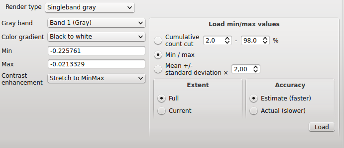
QGIS by default computes min/max using by default an accuracy that is set to "estimated (faster)" and this gives "wrong" results, but if you switch to "Actual (slower)" then the values are the same as gdalinfo (both for single files or vrt rasters).
I think that we can argue why using "estimated" by default and why this give min/max values that are so different (at least in cases as your dataset) from real values. I guess we have to choose another title/description for this ticket if decide that this is indeed worth to be left open.
Note:
at this point #14853 is another issue: in the histogram graph min/max markers/graph are always set to the values computed as "estimated" even if the numeric values are the ones computed as "actual".
#9
Updated by Giovanni Manghi almost 10 years ago
- Tracker changed from Bug report to Feature request
- Status changed from Feedback to Open
#10
Updated by Giovanni Manghi about 9 years ago
- Easy fix? set to No
#11
 Updated by Jürgen Fischer about 9 years ago
- Related to Bug report #14853: Histogram min/max values markers and graph are always the ones for values computed as "estimated" added
#12
Updated by Jürgen Fischer about 9 years ago
- Description updated (diff)