Bug report #1452

crash loading big shapefile
| Status: | Closed | ||
|---|---|---|---|
| Priority: | Low | ||
| Assignee: | |||
| Category: | - | ||
| Affected QGIS version: | Regression?: | No | |
| Operating System: | Debian | Easy fix?: | No |
| Pull Request or Patch supplied: | Resolution: | fixed | |
| Crashes QGIS or corrupts data: | Copied to github as #: | 11512 |
Description
QGIS crashes loading a 382 MB shapefile, 180514 polygons:
$ ogrinfo -al -so neg_patch_poly_bnd_area_splt

INFO: Open of @robota/fucha/2008_javier/neg_patch_poly_bnd_area_splt'
      using driver @ESRI Shapefile' successful.

Layer name: neg_patch_poly_bnd_area_splt
Geometry: Polygon
Feature Count: 180514
Extent: (-180.000000, -90.000000) - (180.000000, 90.000000)
Layer SRS WKT:
GEOGCS["GCS_WGS_1984",
    DATUM["WGS_1984",
        SPHEROID[[WGS_1984]],
    PRIMEM[[Greenwich]],
    UNIT[[Degree]]
cat: Real (11.0)
Backtrace:
Program received signal SIGSEGV, Segmentation fault.
[Switching to Thread 0x7f6abcda2710 (LWP 21711)]
0x00007f6abb8f80fc in ?? () from /usr/lib/libQtGui.so.4
(gdb) bt
#0  0x00007f6abb8f80fc in ?? () from /usr/lib/libQtGui.so.4
#3905  0x00007f6abb8c1295 in ?? () from /usr/lib/libQtGui.so.4
#3906  0x00007f6abb8bde4f in QStroker::processCurrentSubpath ()
   from /usr/lib/libQtGui.so.4
#3907  0x00007f6abb8beee0 in QStrokerOps::strokePath ()
   from /usr/lib/libQtGui.so.4
#3908  0x00007f6abb8f758a in ?? () from /usr/lib/libQtGui.so.4
#3909  0x00007f6abc6d38ef in [[QgsVectorLayer]]::drawPolygon (this=0x2b2b980,
    feature=0x7f6a69433010 "\\001\\003", p=0x7fffc4edde70, mtp=0x1fa2c78,
    ct=0x0, drawingToEditingCanvas=true)
    at /home/shoofi/src/straight/qgis-trunk/src/core/qgsvectorlayer.cpp:649
#3910  0x00007f6abc6d4908 in [[QgsVectorLayer]]::drawFeature (this=0x2b2b980,
    p=0x7fffc4edde70, fet=@0x7fffc4edd8d0, theMapToPixelTransform=0x1fa2c78,
    ct=0x0, marker=0x7fffc4edd920, widthScale=3.8582677165354333,
    rasterScaleFactor=1, drawingToEditingCanvas=true)
    at /home/shoofi/src/straight/qgis-trunk/src/core/qgsvectorlayer.cpp:3389
#3911  0x00007f6abc6d5043 in [[QgsVectorLayer]]::draw (this=0x2b2b980,
    rendererContext=@0x1fa2c38)
    at /home/shoofi/src/straight/qgis-trunk/src/core/qgsvectorlayer.cpp:767
#3912  0x00007f6abc685776 in [[QgsMapRenderer]]::render (this=0x1fa2ba0,
    painter=0x7fffc4edde70)
    at /home/shoofi/src/straight/qgis-trunk/src/core/qgsmaprenderer.cpp:340
#3913  0x00007f6abca85049 in [[QgsMapCanvasMap]]::render (this=0x1fc0630)
    at /home/shoofi/src/straight/qgis-trunk/src/gui/qgsmapcanvasmap.cpp:84
#10 0x00007f6abca7fc72 in [[QgsMapCanvas]]::refresh (this=0x1f99700)
    at /home/shoofi/src/straight/qgis-trunk/src/gui/qgsmapcanvas.cpp:365
#3914 0x00000000004c517e in [[QgisApp]]::addVectorLayers (this=0x1eee610,
    theLayerQStringList=@0x7fffc4ede1a0, enc=@0x7fffc4ede190)
    at /home/shoofi/src/straight/qgis-trunk/src/app/qgisapp.cpp:2171
#3915 0x00000000004c6c64 in [[QgisApp]]::addVectorLayer (this=0x1eee610)
    at /home/shoofi/src/straight/qgis-trunk/src/app/qgisapp.cpp:2109
#3916 0x000000000069b636 in [[QgisApp]]::qt_metacall (this=0x1eee610,
    _c=QMetaObject::InvokeMetaMethod, _id=86, _a=0x7fffc4ede3b0)
    at /home/shoofi/src/straight/qgis-trunk/build/src/app/moc_qgisapp.cxx:328
#3917 0x00007f6abc27c6d4 in QMetaObject::activate () from /usr/lib/libQtCore.so.4
#3918 0x00007f6abb786d77 in QAction::triggered () from /usr/lib/libQtGui.so.4
#3919 0x00007f6abb787540 in QAction::activate () from /usr/lib/libQtGui.so.4
#3920 0x00007f6abba97cca in ?? () from /usr/lib/libQtGui.so.4
#3921 0x00007f6abba97f65 in QAbstractButton::mouseReleaseEvent ()
   from /usr/lib/libQtGui.so.4
#3922 0x00007f6abbb5f74a in QToolButton::mouseReleaseEvent ()
   from /usr/lib/libQtGui.so.4
#3923 0x00007f6abb7df139 in QWidget::event () from /usr/lib/libQtGui.so.4
#3924 0x00007f6abb78ca5d in QApplicationPrivate::notify_helper ()
   from /usr/lib/libQtGui.so.4
#3925 0x00007f6abb79504a in QApplication::notify () from /usr/lib/libQtGui.so.4
#3926 0x00007f6abc638ebe in [[QgsApplication]]::notify (this=0x7fffc4edfc20,
    receiver=0x1f6f710, event=0x7fffc4eded40)
    at /home/shoofi/src/straight/qgis-trunk/src/core/qgsapplication.cpp:78
#3927 0x00007f6abc268381 in QCoreApplication::notifyInternal ()
   from /usr/lib/libQtCore.so.4
#3928 0x00007f6abb7943e8 in QApplicationPrivate::sendMouseEvent ()
   from /usr/lib/libQtGui.so.4
#3929 0x00007f6abb7f8909 in ?? () from /usr/lib/libQtGui.so.4
#3930 0x00007f6abb7f77ff in QApplication::x11ProcessEvent ()
   from /usr/lib/libQtGui.so.4
#3931 0x00007f6abb81ec84 in ?? () from /usr/lib/libQtGui.so.4
#3932 0x00007f6ab80c778b in g_main_context_dispatch ()
   from /usr/lib/libglib-2.0.so.0
#3933 0x00007f6ab80caf5d in ?? () from /usr/lib/libglib-2.0.so.0
#3934 0x00007f6ab80cb11b in g_main_context_iteration ()
   from /usr/lib/libglib-2.0.so.0
#3935 0x00007f6abc29070f in QEventDispatcherGlib::processEvents ()
   from /usr/lib/libQtCore.so.4
#3936 0x00007f6abb81e44f in ?? () from /usr/lib/libQtGui.so.4
#3937 0x00007f6abc266ca2 in QEventLoop::processEvents ()
   from /usr/lib/libQtCore.so.4
#3938 0x00007f6abc266e2d in QEventLoop::exec () from /usr/lib/libQtCore.so.4
#36 0x00007f6abc2692dd in QCoreApplication::exec ()
   from /usr/lib/libQtCore.so.4
#37 0x00000000004b5639 in main (argc=1, argv=0x7fffc4ee0318)
    at /home/shoofi/src/straight/qgis-trunk/src/app/main.cpp:683
Debian testing amd64, QGIS SVN trunk r9770, QT 4.4.3, GDAL 1.6 SVN trunk r15902 (05.12.2008).
History
#1
 Updated by Horst Düster over 17 years ago
Works for me. I just loaded a shape with size of 1.2GB and more than 1000000 polygons without any problems regardless whether I use on the fly projection to WGS84 or not. Did you check your data?
#2
 Updated by Maciej Sieczka - over 17 years ago
Replying to [comment:1 hdus]:
Works for me. I just loaded a shape with size of 1.2GB and more than 1000000 polygons without any problems regardless whether I use on the fly projection to WGS84 or not. Did you check your data?
The data is OK AFAICT. I can easily process it with OGR tools, export/import in GRASS. Will soon try rendering with MapServer and I'll post the result if I remember to.
Interesting - the Shapefile crashes whole Xorg (!!!) if "Fix problems..." is set ON in Options>Rendering, and only crashes QGIS alone if the option is set OFF.
I can't share the data in public. It's for sale. I could share it with an interested QGIS developer in private if he promises not to redistribute it.
#3
Updated by Horst Düster over 17 years ago
Replying to [comment:2 msieczka]:
Replying to [comment:1 hdus]:
Works for me. I just loaded a shape with size of 1.2GB and more than 1000000 polygons without any problems regardless whether I use on the fly projection to WGS84 or not. Did you check your data?
The data is OK AFAICT. I can easily process it with OGR tools, export/import in GRASS. Will soon try rendering with MapServer and I'll post the result if I remember to.
Interesting - the Shapefile crashes whole Xorg (!!!) if "Fix problems..." is set ON in Options>Rendering, and only crashes QGIS alone if the option is set OFF.
That's the difference to my attempt. I had swiched off this option. Now I switched "Fix problems ..." on, but every works fine for me.
I can't share the data in public. It's for sale. I could share it with an interested QGIS developer in private if he promises not to redistribute it.
#4
Updated by Maciej Sieczka - over 17 years ago
I have isolated the smalest single polygon that crashes Xorg when loaded to QGIS. It's 2.5 MB. You can download it at http://www.sieczka.org/tmp/feat_8.7z (0.5 MB). It's a subset of the big Shapefile I originaly reported about. I have 4 more such polygons (larger though) if needed.
ogr2ogr can process the polygon just fine. It also renders OK with MapServer's shp2img. As well as QGIS with "Fix problems..." set ON in Options>Rendering set OFF.
Yet it constantly crashes Xorg when loaded to QGIS with "Fix problems..." set ON. Differently than with the original big shapefile, if "Fix problems..." is set OFF there's no crash with this single polygon. After looking more into this, it showed that the original big shapefile crashes QGIS because the memory runs out.
So probably two issues here - QGIS crashes when it runs out of memory with big shapefiles AND it makes Xorg crash rendering certain shapes.
#5
 Updated by Paolo Cavallini over 17 years ago
The shp causing the crash is no longer available. Is the bug still valid? Please check, and if it is, make the shp available (if not, just close the ticket).
Thanks
#6
Updated by Paolo Cavallini about 17 years ago
- Resolution set to worksforme
- Status changed from Open to Closed
According to our new bug policy, I'm closing this pending feedback from the user. In case it is still valid, please reopen it. Sorry for the additional trouble.
#7 Updated by Anonymous almost 17 years ago
Milestone Version 1.0.2 deleted
#8
 Updated by sieczka - almost 17 years ago
- Status changed from Closed to Feedback
- Resolution deleted (
worksforme)
Replying to [comment:5 pcav]:
The shp causing the crash is no longer available. Is the bug still valid? Please check, and
if it is, make the shp available (if not, just close the ticket).
I can again reproduce the crash with GSSHS 2.0 Shapefiles: ftp://ftp.soest.hawaii.edu/pwessel/gshhs/GSHHS_shp_2.0.zip.
QGIS trunk , GDAL 1.6.2, QT 4.4.3, GEOS 3.1.0, Debian stable amd64.
#9
 Updated by Giovanni Manghi almost 17 years ago
Hi,
I have loaded all the shapes included in the archive you linked (including a a 180000 polygon one) and I have no crashes. Qgis trunk compiled under ubuntu 9.04 32 bit with 512mb of ram.
#10
Updated by Giovanni Manghi almost 17 years ago
Tested also under windows xp 32 bit, 512mb of ram with qgis 1.2 (osgeo4w). No problems at all.
Can anyone on a 64bit platform make a test and report back? Thanks.
#11
 Updated by luca76 - almost 17 years ago
- Resolution set to fixed
- Status changed from Feedback to Closed
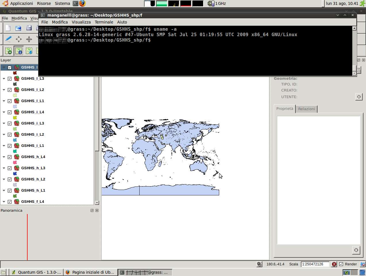
Works to me on x64 system, with QGIS trunk. See my attachment.
[https://trac.osgeo.org/qgis/attachment/ticket/1452/Schermata.jpg]
closed fixed.