Bug report #9216

The map becomes black when scale is > 1:1600
| Status: | Closed | ||
|---|---|---|---|
| Priority: | Normal | ||
| Assignee: | - | ||
| Category: | Map Canvas | ||
| Affected QGIS version: | 2.0.1 | Regression?: | No |
| Operating System: | Easy fix?: | No | |
| Pull Request or Patch supplied: | No | Resolution: | not reproducable |
| Crashes QGIS or corrupts data: | No | Copied to github as #: | 17839 |
Description
Hi,
I use some XML files to display TMS in QGIS like these files :
http://www.gdal.org/frmt_wms.html
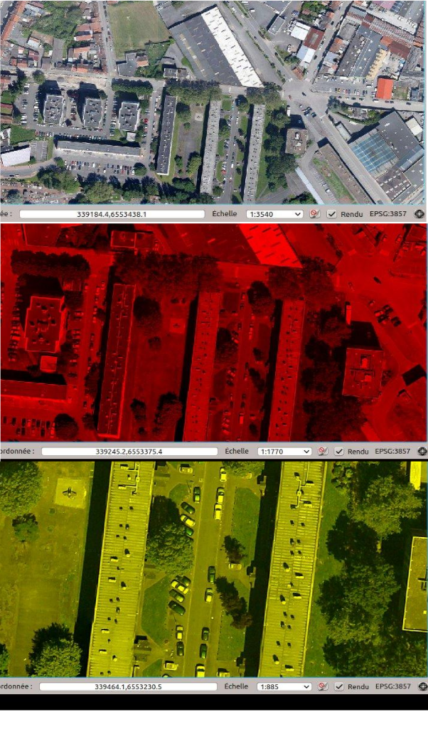
If I zoom to much on the layer (I guess when no tiles are available on the server side : z18 for instance), my map canvas becomes black or colors are like a rainbow.
Tiles should be resized.
Regards

History
#1
 Updated by Richard Duivenvoorde about 12 years ago
hi Etienne,
I cannot reproduce your problem here. Both in 2.0.1 and in QGIS testing, using your osmfr.xml I can zoom in till pixel/1:1 zoom level.
I think QGIS is just reading the rasters it gets from GDAL. So maybe you are running a different version of GDAL?
Can you give some more info about versions/OS that you do. Maybe upload an screendump?
In the about box you can find that info. Mine shows:
QGIS version 2.0.1-Dufour QGIS code revision c2d5400
Compiled against Qt 4.8.6 Running against Qt 4.8.6
Compiled against GDAL/OGR 1.9.0 Running against GDAL/OGR 1.9.0
Compiled against GEOS 3.3.3-CAPI-1.7.4 Running against GEOS 3.3.3-CAPI-1.7.4
PostgreSQL Client Version 9.3.1 SpatiaLite Version 3.1.0-RC2
QWT Version 5.2.3 PROJ.4 Version 470
QScintilla2 Version 2.7.2 This copy of QGIS writes debugging output.
#2
 Updated by Etienne Trimaille about 12 years ago
- File OSM.png added
- File google.png added
I have GDAL 1.9.0
One of my friend has the same bug, I'm sure he has 1.10 (I'm going to ask him).
My about box :
Version de QGIS 2.0.1-Dufour Révision du code exported
Compilé avec Qt 4.8.4 Utilisant Qt 4.8.4
Compilé avec GDAL/OGR 1.9.0 Utilisé avec GDAL/OGR 1.9.0
Compiled against GEOS 3.3.3-CAPI-1.7.4 Running against GEOS 3.3.3-CAPI-1.7.4
Version du client PostgreSQL 9.1.9 Version de SpatiaLite 3.1.0-RC2
Version de QWT 5.2.3 Version de PROJ.4 : 470
Version de QScintilla2
I tried to understand when this bug occur precisely with Google and OSM layers.
#3
Updated by Etienne Trimaille over 10 years ago
- Status changed from Open to Closed
I can't replicate it anymore.
#4
 Updated by Giovanni Manghi over 10 years ago
- Resolution set to not reproducable