Bug report #4049

Trouble Symbolizing Fields in a Joined Table QGIS 1.7
| Status: | Closed | ||
|---|---|---|---|
| Priority: | Normal | ||
| Assignee: | - | ||
| Category: | Symbology | ||
| Affected QGIS version: | master | Regression?: | No |
| Operating System: | Ubuntu 10.04, Windows XP | Easy fix?: | No |
| Pull Request or Patch supplied: | No | Resolution: | fixed/implemented |
| Crashes QGIS or corrupts data: | No | Copied to github as #: | 14035 |
Description
Using the latest version of QGIS (1.7 Wroclaw) and am running into two problems with the new table joining feature. The trouble occurs after I join my DBF or CSV (with CSVT) to a shapefile. The join is successful;, the trouble occurs when I go to symbolize the data in the joined attribute table. If I choose graduated symbols and specify some classes:
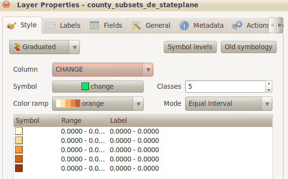
1. Under the old symbology, equal intervals does not work. All the classes are populated with zeros. Quantiles works perfectly fine.
2. Under the new symbology, equal intervals still doesn't work (populating with zeros) AND quantiles and natural breaks don't work correctly - my dataset has negative values in it, and these values are simply dropped rather than classified.
I've noticed that I am able to symbolize attributes that are part of the original shapefile; it's just attributes that are part of the table that don't work. After doing the join, I've also noticed that if I look at the Fields tab for the layer, the fields in the shapefile have values for precision and length, but the fields from the joined table have values of zero. I've gotten around the problem by doing the join, and doing a Save As on the shapefile to create a new shapefile with the attributes of the table permanently fused to the file. The symbolization works fine then, and the attributes are assigned precision and length.
I've tried this using DBF and CSV, with the same result. I've tested this using 1.7 in both Ubuntu 10.04 (Lucid Lynx) and Windows XP (SP3). Same result.
I've attached a ZIP file with the shapefile and data tables if you want to try it out. The files are projected in EPSG 2235 (Delaware State Plane ft). Try joining the county_subsets shapefile to the de_2010_pop table (dbf or csv). Join fields: GEO_ID2 in the table and GEOID10 in the shapefile. Then try symbolizing graduated colors for the CHANGE OR PCTCHANGE fields in the table.
Originally posted this on the forum, [http://forum.qgis.org/viewtopic.php?f=2&t=8916] and was suggested to create this ticket.
History
#1
 Updated by Anita Graser almost 15 years ago
- Target version set to Version 1.7.1
- Must fix set to yes
#2
 Updated by Tim Sutton over 14 years ago
- Target version changed from Version 1.7.1 to Version 1.7.2
#3
 Updated by Giovanni Manghi over 14 years ago
- Target version changed from Version 1.7.2 to Version 1.7.3
#4
Updated by Giovanni Manghi over 14 years ago
- Target version changed from Version 1.7.3 to Version 1.7.4
#5
 Updated by Paolo Cavallini about 14 years ago
- Affected QGIS version set to master
- Crashes QGIS or corrupts data set to No
- Target version changed from Version 1.7.4 to Version 1.8.0
#6
Updated by Paolo Cavallini over 13 years ago
- Target version changed from Version 1.8.0 to Version 2.0.0
#7
 Updated by Jürgen Fischer almost 12 years ago
- Target version changed from Version 2.0.0 to Future Release - Lower Priority
#8
Updated by Giovanni Manghi almost 11 years ago
- Pull Request or Patch supplied set to No
- Status changed from Open to Closed
- Resolution set to fixed/implemented