Bug report #20107

Inconsistent number of decimal places in Identify tool
| Status: | Open | ||
|---|---|---|---|
| Priority: | Normal | ||
| Assignee: | - | ||
| Category: | Map Tools | ||
| Affected QGIS version: | 3.6.0 | Regression?: | No |
| Operating System: | Easy fix?: | No | |
| Pull Request or Patch supplied: | Yes | Resolution: | |
| Crashes QGIS or corrupts data: | No | Copied to github as #: | 27929 |
Description
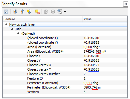
In QGIS 3.3.0-Master, using the Identify tool, the Length, Area and Perimeter values are displayed always with 3 decimal places, while the other values are displayed according to the settings in Project Properties | General | Coordinate Display | Precision.
PR https://github.com/qgis/QGIS/pull/7836 previously created.
History
#1
 Updated by Andrea Giudiceandrea over 7 years ago
- Description updated (diff)
#2
Updated by Andrea Giudiceandrea over 7 years ago
- Description updated (diff)
#3
Updated by Andrea Giudiceandrea over 7 years ago
- Affected QGIS version changed from 3.3(master) to 3.4.0
Confirmed on 3.4.0
#5
 Updated by Giovanni Manghi over 7 years ago
- Affected QGIS version changed from 3.4.0 to 3.6.0
- Status changed from Feedback to Open
This is still true in the latest versions, not sure why the PR was closed.