Bug report #19753

Adding delimited text no longer adds geometry
| Status: | Closed | ||
|---|---|---|---|
| Priority: | Normal | ||
| Assignee: | - | ||
| Category: | Data Provider/Delimited Text | ||
| Affected QGIS version: | 3.2.2 | Regression?: | No |
| Operating System: | Easy fix?: | No | |
| Pull Request or Patch supplied: | No | Resolution: | invalid |
| Crashes QGIS or corrupts data: | No | Copied to github as #: | 27578 |
Description
Since 31 August 2018 I've been trying to load csv data into QGIS (3.2.2 Bonn) following the usual routine. Every single time, when I identify the geometry as points, and include longitude and latitude as x and y respectively, it loads the csv as a table with no geometry. I have reinstalled v3.2.2 Bonn twice, including a fresh download this morning, and the issue is persistent.
Strangely enough, I was working with the same set of files in v3.2.2 on 30 August and the import and visualisation worked perfectly. As well as a fix to the glitch, I'd like to know how a glitch emerged overnight without me doing anything.
Map_data.csv  (736 Bytes)
screencap_1.jpg - data loading (671 KB)
screencap_2.jpg - layer properties (619 KB)
History
#1
 Updated by Nyall Dawson almost 8 years ago
- Status changed from Open to Feedback
Does your source csv have any date attributes? Can you share it?
#2
 Updated by Sean Tomlinson almost 8 years ago
- File Map_data.csv added
By "date attributes" do you mean timestamps?
Almost invariably not. Usually they're point layers representing raster grids, but it doesn't seem to matter because none of my csv files load up correctly anymore. In this case I've been trying to upload study sites (see attached example). Here I loaded the csv, assigned longitude as the x and latitude as the y, and ended up with a data table with no geometry.
Also, I have reinstalled QGIS several times, and have removed and reinstalled all the registry files. It makes no difference, I get the same problem every time
#3
 Updated by Giovanni Manghi almost 8 years ago
- Category changed from Geometry to Data Provider/Delimited Text
Sean Tomlinson wrote:
By "date attributes" do you mean timestamps?
Almost invariably not. Usually they're point layers representing raster grids, but it doesn't seem to matter because none of my csv files load up correctly anymore. In this case I've been trying to upload study sites (see attached example). Here I loaded the csv, assigned longitude as the x and latitude as the y, and ended up with a data table with no geometry.
Also, I have reinstalled QGIS several times, and have removed and reinstalled all the registry files. It makes no difference, I get the same problem every time
your data work just fine here on QGIS master on Linux.
#4
 Updated by Johannes Kroeger almost 8 years ago
Can you share a screenshot of your delimited text loader dialog?
#5
Updated by Sean Tomlinson almost 8 years ago
- File screencap_1.jpg added
- File screencap_2.jpg added
I knew it would be like this. I'm doing nothing new, and nothing differently to what has always worked before.
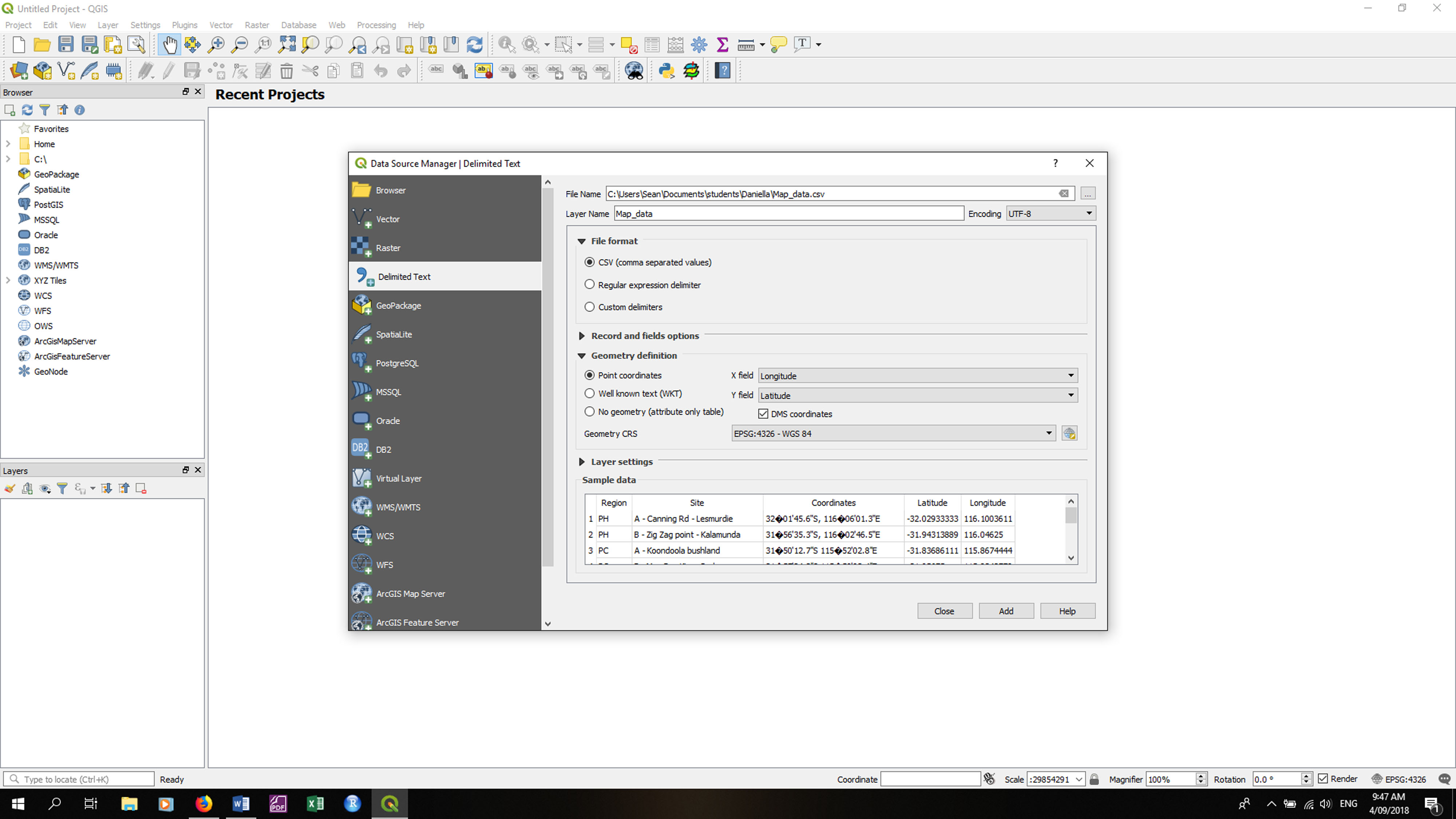
I've included a screen capture of the dialogue box where I'm loading the data (screencap_1), where you can see that I've loaded the data as point geometry with latitude and longitude in the appropriate places. The CRS is WGS84, which is again the projection that I've always used for all my stuff without a problem.
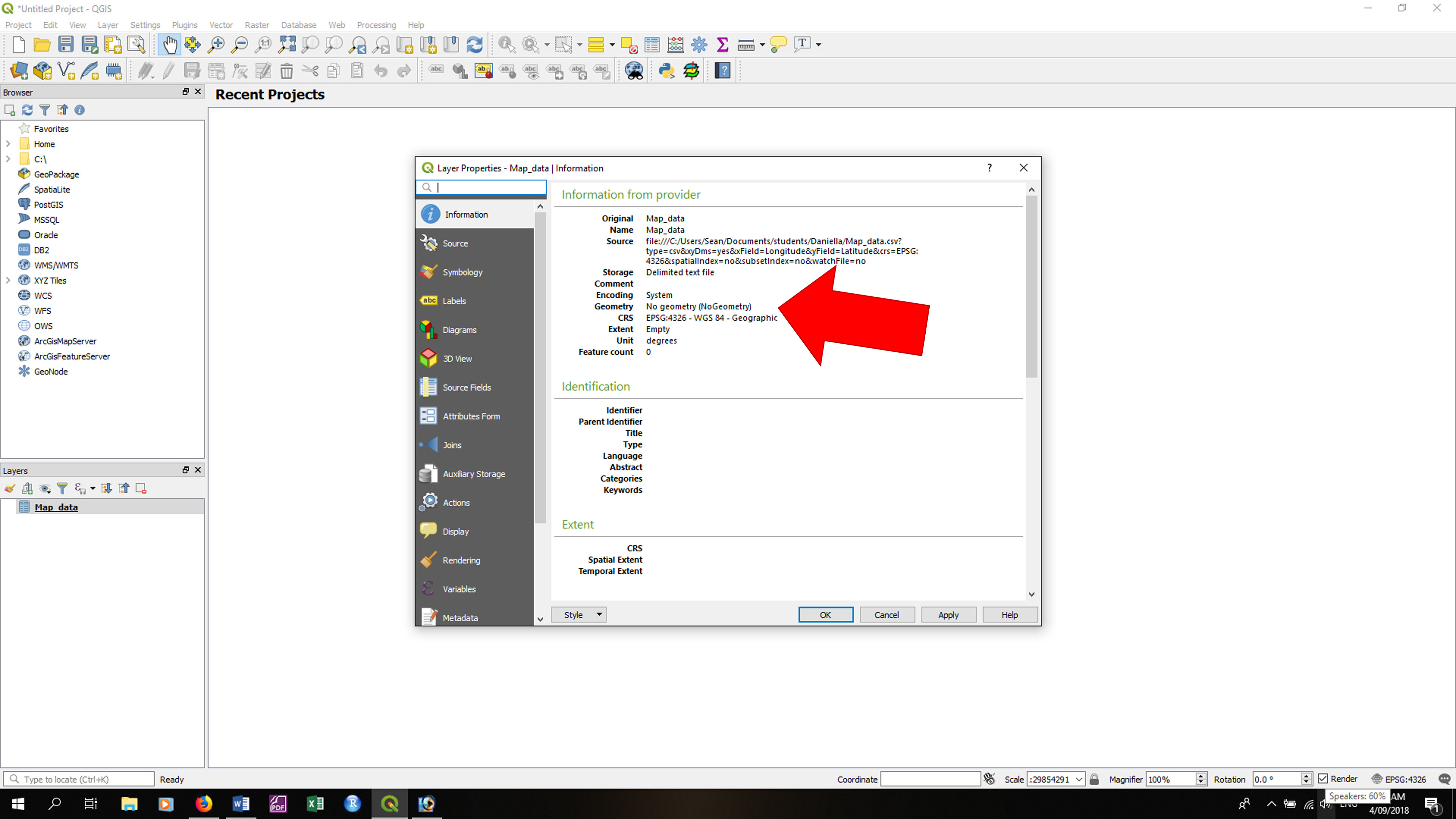
You'll see in screencap_2 the layer properties dialogue box. The big red arrow is something that I added myself to point out the problem. The layer has no geometry, even though I gave it an appropriate point geometry when I was loading it up.
This now happens every single time I try to upload any delimited text into QGIS. I've reinstalled 4 times now, including a complete removal of all QGIS registry files, and it still does this every time. My current workaround is to open all my delimited files in R, convert to shapefiles, open in QGIS, do whatever I needed to do, then convert the shapefiles back to delimited files in R. Given that some of my files contain several hundred thousand data points, it's hardly efficient. Anybody who has any ideas I'd be grateful, but right now I'm thinking of copying QGIS onto a memory stick and burning it in an attempt to appease whichever foul devilry has hijacked my stuff.
#6
Updated by Giovanni Manghi almost 8 years ago
- Resolution set to invalid
- Status changed from Feedback to Closed
The issue is that you have the "DMS coordinates" checkbox active and you are selecting two columns for X/Y that have NOT coordinate in DMS (they are in DD).