Bug report #19327

problems with network paths in inputs for GDAL Processing tools
| Status: | Closed | ||
|---|---|---|---|
| Priority: | High | ||
| Assignee: | - | ||
| Category: | Processing/GDAL | ||
| Affected QGIS version: | 3.2 | Regression?: | Yes |
| Operating System: | Windows 7 | Easy fix?: | No |
| Pull Request or Patch supplied: | No | Resolution: | fixed/implemented |
| Crashes QGIS or corrupts data: | No | Copied to github as #: | 27155 |
Description
New description:
Old description:
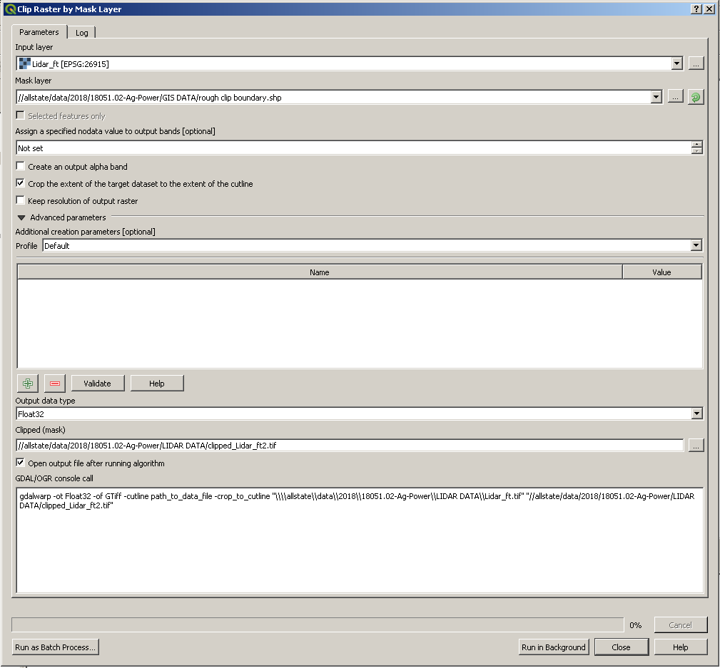
I am able to use newly created polygons as mask layers in the 'Clip raster by mask layer' command.
Processing algorithm…
Algorithm 'Clip raster by mask layer' starting…
Input parameters:
{ 'ALPHA_BAND' : False, 'CROP_TO_CUTLINE' : True, 'DATA_TYPE' : 5, 'INPUT' : '//allstate/data/2018/18051.02-Ag-Power/LIDAR DATA/Lidar_ft.tif', 'KEEP_RESOLUTION' : False, 'MASK' : '\\allstate\data\2018\18051.02-Ag-Power\GIS DATA\rough clip boundary.shp', 'NODATA' : None, 'OPTIONS' : '', 'OUTPUT' : '//allstate/data/2018/18051.02-Ag-Power/LIDAR DATA/clipped_Lidar_ft.tif' }

GDAL command:
gdalwarp -ot Float32 -of GTiff -cutline "\\\\allstate\\data\\2018\\18051.02-Ag-Power\\GIS DATA\\rough clip boundary.shp" -crop_to_cutline "//allstate/data/2018/18051.02-Ag-Power/LIDAR DATA/Lidar_ft.tif" "//allstate/data/2018/18051.02-Ag-Power/LIDAR DATA/clipped_Lidar_ft.tif"
GDAL command output:
*ERROR 1: Cannot open \\\\allstate\\data\\2018\\18051.02-Ag-Power\\GIS DATA\\rough clip boundary.shp.*

Execution completed in 0.07 seconds
Results:
{'OUTPUT': <QgsProcessingOutputLayerDefinition {'sink'://allstate/data/2018/18051.02-Ag-Power/LIDAR DATA/clipped_Lidar_ft.tif, 'createOptions': {'fileEncoding': 'System'}}>}

Loading resulting layers
The following layers were not correctly generated.<ul><li>//allstate/data/2018/18051.02-Ag-Power/LIDAR DATA/clipped_Lidar_ft.tif</li></ul>You can check the 'Log Messages Panel' in QGIS main window to find more information about the execution of the algorithm.
History
#1
 Updated by Giovanni Manghi about 8 years ago
- Status changed from Open to Feedback
Can you please add detalied/extact steps/data to allow us replicate? thanks!
#2
 Updated by Nyall Dawson about 8 years ago
Two things to check:
1. Is //allstate/data/2018/18051.02-Ag-Power/LIDAR DATA/clipped_Lidar_ft.tif actually created?
2. If you run the gdal command from the log directly in a command line, what happens? Can you determine what changes are required to the command to run correctly?
#3
 Updated by Michael Harrington about 8 years ago
- File qgis3ClipRasterFixed.PNG added
- File qgis3ClipRasterBroken.PNG added
- File qgis2ClipRaster.PNG added
- File qgis3ClipRasterLog.PNG added
Nyall Dawson wrote:
Two things to check:
1. Is //allstate/data/2018/18051.02-Ag-Power/LIDAR DATA/clipped_Lidar_ft.tif actually created?
2. If you run the gdal command from the log directly in a command line, what happens? Can you determine what changes are required to the command to run correctly?
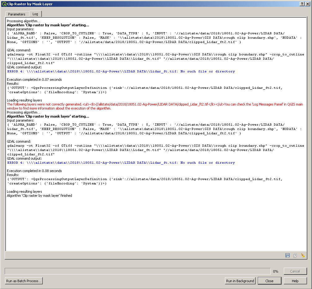
1. The clipped_Lidar_ft.tif is never actually created, but the "rough clip boundary.shp" is a real polygon that was created already.
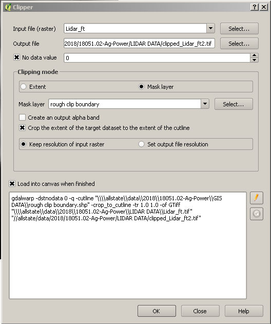
2. I checked QGIS 2.14.5 and this command worked as it normally does. Attached is a screenshot of the command I used for that.
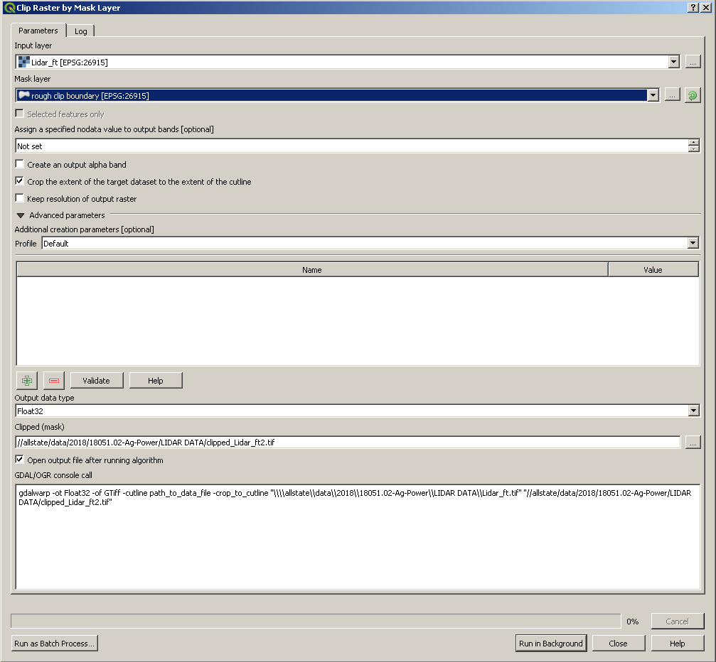
I also attached a screenshot of the broken command in QGIS 3.2. I figured out a work around as well. Instead of using the drop down for the Mask layer, if I browse to the rough clipped boundary the command works properly. Attached is also the Fixed prompt used in QGIS 3.2.
I also attached the log of both the normal prompt that is broken and the work around prompt that is fixed.
#4
Updated by Giovanni Manghi about 8 years ago
so... if I understad coorectly: the paths are network ones, and in this case if the input is selected using the dropdown the tool does not work, if you open the dialog to get pick the layer in the network folder it works. That's it?
#5
Updated by Michael Harrington about 8 years ago
Giovanni Manghi wrote:
so... if I understad coorectly: the paths are network ones, and in this case if the input is selected using the dropdown the tool does not work, if you open the dialog to get pick the layer in the network folder it works. That's it?
Yes, that seems to be what is happening.
#6
Updated by Giovanni Manghi about 8 years ago
- Subject changed from Unable to open created clip boundary for 'Clip raster by mask layer' to problems with network paths in inputs for GDAL Processing tools
- Priority changed from Normal to High
- Status changed from Feedback to Open
- Category changed from Actions to Processing/GDAL
- Description updated (diff)
#7
 Updated by Jürgen Fischer about 8 years ago
- Description updated (diff)
#8
Updated by Michael Harrington almost 8 years ago
Could this issue have anything to do with the lack of mapping the network drive?
#9
Updated by Nyall Dawson over 7 years ago
- Resolution set to fixed/implemented
- Status changed from Open to Closed
This is fixed in 3.4