Bug report #19016

Limits in labels for raster symbology in discrete interpolation method are not shown
| Status: | Open | ||
|---|---|---|---|
| Priority: | High | ||
| Assignee: | - | ||
| Category: | Symbology | ||
| Affected QGIS version: | 3.6.0 | Regression?: | Yes |
| Operating System: | Easy fix?: | No | |
| Pull Request or Patch supplied: | No | Resolution: | |
| Crashes QGIS or corrupts data: | No | Copied to github as #: | 26847 |
Description
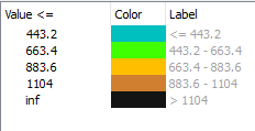
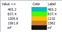
In QGIS 2.18, when the discrete interpolation method was selected for a raster, the labels used to show the lower and the upper limits. This is not the case with QGIS 3.03
History
#1
 Updated by Alister Hood almost 7 years ago
- Regression? changed from No to Yes
#2
 Updated by Giovanni Manghi almost 7 years ago
- Affected QGIS version changed from 3.0.3 to 3.6.0
- Priority changed from Normal to High