Bug report #18873

XYZ Tile Server with custom CRS not working in 2.18 LTS
| Status: | Open | ||
|---|---|---|---|
| Priority: | Normal | ||
| Assignee: | - | ||
| Category: | Web Services clients/XYZ | ||
| Affected QGIS version: | 3.4.4 | Regression?: | No |
| Operating System: | Linux Ubuntu 18.04 LTS | Easy fix?: | No |
| Pull Request or Patch supplied: | No | Resolution: | |
| Crashes QGIS or corrupts data: | No | Copied to github as #: | 26705 |
Description
I have added the following URL pattern as an XYZ Tile Server connection:
An example tile is at http://dcw7.digimap.je/arcgis/rest/services/StatesOfJersey/JerseyAerialPhotoOL2014_500/MapServer/tile/0/268/331
When I add the layer no tiles are rendered on my map.
I have successfully added other tile layers, which work: e.g. https://server.arcgisonline.com/ArcGIS/rest/services/World_Topo_Map/MapServer/tile/{z}/{y}/{x}.png
The Map Server I am trying to add uses a custom CRS: EPSG:3109 (which uses a custom map origin). I have this CRS set in my project and on the fly projection enabled.
When added, the layer does not pick up the custom CRS, but instead uses EPSG:3857. Changing to the correct CRS in the added layer does not resolve the problem.
I note that the Server specifies 9 zoom levels, with 0 scaled at 1:250,000.
Does 2.18 LTS support Tile Servers with custom CRS & scales and if not does QGIS 3 do so?
Steps to reproduce above and no known workaround.
Many thanks.
History
#1
 Updated by Bruce Steedman about 8 years ago
Related to #18881 re incorrect crs parsed from ESRI wkt on server.
Also, problem still exists in QGIS v3.02 on Ubuntu 18.04 LTS.
#2
 Updated by Jürgen Fischer over 7 years ago
- Status changed from Open to Feedback
Please test with QGIS 3.4 - QGIS 2.18 reached it's end of life.
#3
Updated by Bruce Steedman over 7 years ago
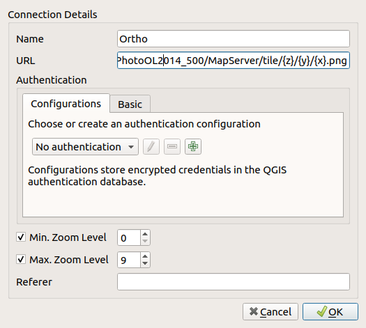
- File xyz.png added
Thanks for looking at this Jürgen.
Just tried with 3.4.4 and the same result. Exactly the same steps as before & this time I set the zoom range to 0 to 9, as per the MapServer (see attached image):
http://dcw7.digimap.je/arcgis/rest/services/StatesOfJersey/JerseyAerialPhotoOL2014_500/MapServer (note custom zoom level with 0 being 1:250,000)
However, when I look at the network requests QGIS is making I see requests like this:
GET http://dcw7.digimap.je/arcgis/rest/services/StatesOfJersey/JerseyAerialPhotoOL2014_500/MapServer/tile/15/16336/16425.png - i.e. a zoom level outside of the 0-9 range.
Question: Can QGIS XYZ tile layers deal with custom zoom levels like this and/or is perhaps the root of the problem that the correct CRS (EPSG:3109) is not being read/converted from the MapServer WKT under the 'Spatial Reference' key?
Many thanks
Bruce
#4
Updated by Jürgen Fischer over 7 years ago
- Affected QGIS version changed from 2.18.17 to 3.4.4
- Status changed from Feedback to Open