Bug report #18323

Multi-part Polygon is not mapped with shortest segments
| Status: | Closed | ||
|---|---|---|---|
| Priority: | Normal | ||
| Assignee: | - | ||
| Category: | Projection Support | ||
| Affected QGIS version: | 2.18.16 | Regression?: | No |
| Operating System: | Microsoft Windows Pro 10, version 1709 | Easy fix?: | No |
| Pull Request or Patch supplied: | No | Resolution: | duplicate |
| Crashes QGIS or corrupts data: | No | Copied to github as #: | 26213 |
Description
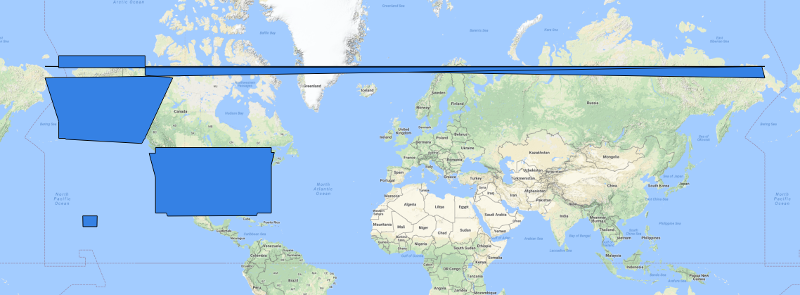
I loaded the edna coverage from USGS into QGIS 2.18.16 and the display with Google Physical as backdrop is attached as an image.
The second polygon from the top is not using shortest path segments to construct the internal area (blue). Seems to me like a major issue if its occurrence within the program is unpredictable.
Related issues
History
#1
 Updated by Michael Miller about 8 years ago
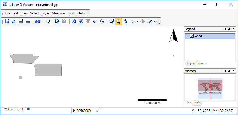
Revision: I misunderstood what I saw earlier. After opening the same file in Tatuk viewer, it looks like the big polygon over Alaska and the small triangle over Siberia are not being separated properly, because they appear to be combined by QGIS into a single polygon. The file is available from the USGS at
https://dds.cr.usgs.gov/ee-data/coveragemaps/shp/ee/edna/edna.zip
#2
 Updated by Giovanni Manghi about 8 years ago
- Priority changed from High to Normal
- Assignee deleted (
Victor Olaya) - Category changed from Processing/Modeller to Projection Support
Michael Miller wrote:
Revision: I misunderstood what I saw earlier. After opening the same file in Tatuk viewer, it looks like the big polygon over Alaska and the small triangle over Siberia are not being separated properly, because they appear to be combined by QGIS into a single polygon. The file is available from the USGS at
https://dds.cr.usgs.gov/ee-data/coveragemaps/shp/ee/edna/edna.zip
the problem is a projection one, you have features crossing the dateline, and they are always a pain. I'm sure there is/are other tickets about it, please try do a search, if you find any close this as duplicate.
#3
Updated by Giovanni Manghi about 8 years ago
- Status changed from Open to Feedback
#4
Updated by Giovanni Manghi almost 8 years ago
- Status changed from Feedback to Closed
- Resolution set to duplicate
Duplicate of #13380
#5
 Updated by Jürgen Fischer almost 8 years ago
- Duplicates Bug report #13380: reprojection of lat/long lines across 180 in mercator map fails added