Bug report #17919

Desktop app: Distance tool does not work
| Status: | Closed | ||
|---|---|---|---|
| Priority: | Normal | ||
| Assignee: | - | ||
| Category: | Unknown | ||
| Affected QGIS version: | 2.18.15 | Regression?: | No |
| Operating System: | Windows 10 64bit | Easy fix?: | No |
| Pull Request or Patch supplied: | No | Resolution: | end of life |
| Crashes QGIS or corrupts data: | No | Copied to github as #: | 25815 |
Description
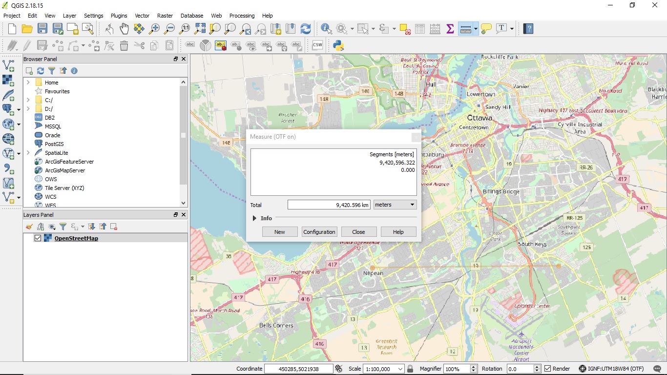
When I use the Distance Tool to measure a distance that I know is 10km on a map, the distance tool give me a value of 3,000 km to 16,000km Moving the cursor just a little causes the value to fluctuate wildly.
I am using QGIS 2.18 on Windows 64. The same issue exists in version 2.14
I have loaded a singe layer with OpenStreetMAp from the OpenLAyer plugin. The layer loads with CRS= WGS/Pseudo Mercator EPSG 3857 and is left unchanged.
I set "on the fly CRS transformation" and set the project/display CRS to UTM-18.
I zoom into an area I know,
The scale dialog says 1:100,000 and this appears correct. also when I move the cursor a distance that I know is 10km the coordinates change by 10,000m as expected.
The Distance Tool and likely other features get the wrong distance (enclosed is a screen shot, The area I'm zoomed in is near 45N 75W )
Sylvain
History
#1
 Updated by Nyall Dawson about 8 years ago
- Status changed from Open to Closed
- Resolution set to invalid
The OpenLayers plugin is very buggy, and causes numerous issues like this - please use the more stable QuickMapServices plugin instead.
#2
 Updated by Jürgen Fischer about 8 years ago
- Subject changed from Desltop app: Distance tool does not work to Desktop app: Distance tool does not work
#3
 Updated by Sylvain DE MARGERIE about 8 years ago
- Status changed from Closed to Reopened
The issue is exactly the same with the QuickMApServices plugin. The issue further propagates to the heatmap plugin which makes it impossible to properly set the radius according to any predictable units.
#4
Updated by Jürgen Fischer about 7 years ago
- Status changed from Reopened to Feedback
Please test with QGIS 3.4 - QGIS 2.18 reached it's end of life.
#5
 Updated by Giovanni Manghi almost 7 years ago
- Resolution changed from invalid to end of life
- Status changed from Feedback to Closed
End of life notice: QGIS 2.18 LTR
Source:
http://blog.qgis.org/2019/03/09/end-of-life-notice-qgis-2-18-ltr/
QGIS 3.4 has recently become our new Long Term Release (LTR) version. This is a major step in our history – a long term release version based on the massive updates, library upgrades and improvements that we carried out in the course of the 2.x to 3x upgrade cycle.
We strongly encourage all users who are currently using QGIS 2.18 LTR as their preferred QGIS release to migrate to QGIS 3.4. This new LTR version will receive regular bugfixes for at least one year. It also includes hundreds of new functions, usability improvements, bugfixes, and other goodies. See the relevant changelogs for a good sampling of all the new features that have gone into version 3.4
Most plugins have been either migrated or incorporated into the core QGIS code base.
We strongly discourage the continued use of QGIS 2.18 LTR as it is now officially unsupported, which means we’ll not provide any bug fix releases for it.
You should also note that we intend to close all bug tickets referring to the now obsolete LTR version. Original reporters will receive a notification of the ticket closure and are encouraged to check whether the issue persists in the new LTR, in which case they should reopen the ticket.
If you would like to better understand the QGIS release roadmap, check out our roadmap page! It outlines the schedule for upcoming releases and will help you plan your deployment of QGIS into an operational environment.
The development of QGIS 3.4 LTR has been made possible by the work of hundreds of volunteers, by the investments of companies, professionals, and administrations, and by continuous donations and financial support from many of you. We sincerely thank you all and encourage you to collaborate and support the project even more, for the long term improvement and sustainability of the QGIS project.