Bug report #17156

Some features not drawn using Oracle as data source
| Status: | Closed | ||
|---|---|---|---|
| Priority: | Normal | ||
| Assignee: | - | ||
| Category: | Map Canvas | ||
| Affected QGIS version: | 2.18.12 | Regression?: | No |
| Operating System: | windows 7 + 10 x64 | Easy fix?: | No |
| Pull Request or Patch supplied: | No | Resolution: | not reproducable |
| Crashes QGIS or corrupts data: | No | Copied to github as #: | 25055 |
Description
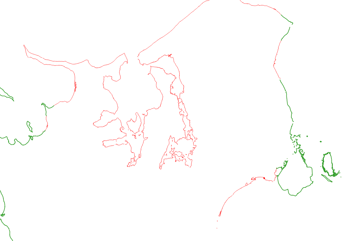
I have some coast line features stored in a Oracle database and I'm trying to show them in QGIS. See the attached image for an example.
I then right-click on the Oracle layer and select 'Save as' and save everything to a SHAPE file. I have dropped the SHAPE file below the Oracle layer in the layer panel.
In the example you can see which features QGIS renders from the Oracle layer (green) and the remaining from the SHAPE layer (red).
I would expect QGIS to render all features. What is missing here?
I have tried the same using QGIS 2.14.18 and 2.14.19 and they crashes when adding the Oracle layer. QGIS 2.18.13 does the same as 2.18.12 and so does MASTER (01468d0879).
History
#1
 Updated by Giovanni Manghi almost 9 years ago
- Priority changed from High to Normal
- Crashes QGIS or corrupts data changed from Yes to No
Just making some guess here... in layer properties do you have the on the fly simplification enabled? are th geometries valid? https://docs.oracle.com/cd/E17952_01/mysql-5.7-en/spatial-convenience-functions.html#function_st-isvalid
#2
 Updated by Casper Børgesen almost 9 years ago
Giovanni Manghi wrote:
Just making some guess here... in layer properties do you have the on the fly simplification enabled? are th geometries valid? https://docs.oracle.com/cd/E17952_01/mysql-5.7-en/spatial-convenience-functions.html#function_st-isvalid
According to FME all features are valid (GeometryValidator with all selected).
Simplification has been turned off in settings and thats probably why its also disabled in the layer properties. I have disabled parallel rendering too.
I haven't changed anything and the problem still persists.
#3
Updated by Giovanni Manghi almost 9 years ago
- Status changed from Open to Feedback
Casper Børgesen wrote:
Giovanni Manghi wrote:
Just making some guess here... in layer properties do you have the on the fly simplification enabled? are th geometries valid? https://docs.oracle.com/cd/E17952_01/mysql-5.7-en/spatial-convenience-functions.html#function_st-isvalid
According to FME all features are valid (GeometryValidator with all selected).
Simplification has been turned off in settings and thats probably why its also disabled in the layer properties. I have disabled parallel rendering too.
I haven't changed anything and the problem still persists.
What about if you re-import the shapefile into the DB? Any chance to attach here the data (I personally have no chance these days to try setup an Oracle instance)?
#4
Updated by Casper Børgesen almost 9 years ago
- Status changed from Feedback to Open
Giovanni Manghi wrote:
Casper Børgesen wrote:
Giovanni Manghi wrote:
Just making some guess here... in layer properties do you have the on the fly simplification enabled? are th geometries valid? https://docs.oracle.com/cd/E17952_01/mysql-5.7-en/spatial-convenience-functions.html#function_st-isvalid
According to FME all features are valid (GeometryValidator with all selected).
Simplification has been turned off in settings and thats probably why its also disabled in the layer properties. I have disabled parallel rendering too.
I haven't changed anything and the problem still persists.
What about if you re-import the shapefile into the DB? Any chance to attach here the data (I personally have no chance these days to try setup an Oracle instance)?
I don't have access to re-import the shapefile into the database.
#5
Updated by Casper Børgesen almost 9 years ago
I zoom to an area containing features that are not rendered. I select (by area) both features which area rendered and features which are not rendered. The features which are rendered are shown as selected. I right click the layer and select "save as" and save only the selected features to as shape file. The shape file contains both the rendered and the not rendered features.
My reason for doing this is to try to eliminate the database if possible. I hope that by selecting a subset of features and saving them, what I actually is saving are the features stored in memory and not acquired directly from the database. I'm not sure though if this is true.
#6
Updated by Giovanni Manghi almost 9 years ago
- Status changed from Open to Feedback
Casper Børgesen wrote:
I zoom to an area containing features that are not rendered. I select (by area) both features which area rendered and features which are not rendered. The features which are rendered are shown as selected. I right click the layer and select "save as" and save only the selected features to as shape file. The shape file contains both the rendered and the not rendered features.
My reason for doing this is to try to eliminate the database if possible. I hope that by selecting a subset of features and saving them, what I actually is saving are the features stored in memory and not acquired directly from the database. I'm not sure though if this is true.
can you attach the (part of) shapefile that concerns the problematic features?
#7
Updated by Casper Børgesen almost 9 years ago
- File qgis_oracle_missing_rendering.prj added
- Status changed from Feedback to Open
- File qgis_oracle_missing_rendering.shx added
- File qgis_oracle_missing_rendering.shp added
- File qgis_oracle_missing_rendering.qpj added
- File qgis_oracle_missing_rendering.dbf added
- File overview.jpg added
Giovanni Manghi wrote:
can you attach the (part of) shapefile that concerns the problematic features?
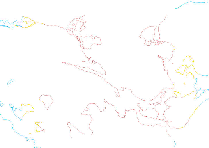
I can attach the SHAPE file I created by selecting the not-rendered features. I have also attached an image showing what is included in the SHAPE file and what is not:
- Blue is from the Oracle database (not included in the SHAPE file).
- Yellow is the default selection color and highlights the visible features from the Oracle database that I have selected (these are included in the SHAPE file).
- Brown is the non-rendered Oracle features which are selected (though not visible, since they would then be yellow) and they are included in the SHAPE file.
#8
Updated by Giovanni Manghi almost 9 years ago
The vector imported in PostGIS shows just fine.
#9
Updated by Casper Børgesen almost 9 years ago
Giovanni Manghi wrote:
The vector imported in PostGIS shows just fine.
Is it possible somehow to make QGIS (master?) provide some information as to why it doesn't want to show them? Maybe it never receives the features or maybe something is wrong with what i does receive?
#10
 Updated by Nyall Dawson about 8 years ago
- Status changed from Open to Feedback
Can you attach WKT or the Oracle geoemtry definition for the features which are missing?
#11
Updated by Casper Børgesen about 8 years ago
Nyall Dawson wrote:
Can you attach WKT or the Oracle geoemtry definition for the features which are missing?
Hi Nyall.
I tried looking into this again, but I cannot reproduce the issue any more (neither in 2.18.18 or master). So I guess you can close this issue (since I cannot).
Thanks for following up on it!
#12
Updated by Nyall Dawson about 8 years ago
- Resolution set to not reproducable
- Status changed from Feedback to Closed