Bug report #15076

Create table dialog lists useless data types for SpatiaLite
| Status: | Closed | ||
|---|---|---|---|
| Priority: | Normal | ||
| Assignee: | - | ||
| Category: | DB Manager | ||
| Affected QGIS version: | 2.14.3 | Regression?: | No |
| Operating System: | Easy fix?: | No | |
| Pull Request or Patch supplied: | No | Resolution: | end of life |
| Crashes QGIS or corrupts data: | No | Copied to github as #: | 23019 |
Description
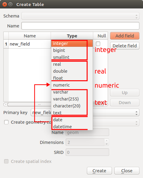
For SpatiaLite the create table dialog should only list the data types integer, text, real and numeric.
See also: http://www.sqlite.com/datatype3.html (3.2. Affinity Name Examples)
History
#1
 Updated by R. R. about 10 years ago
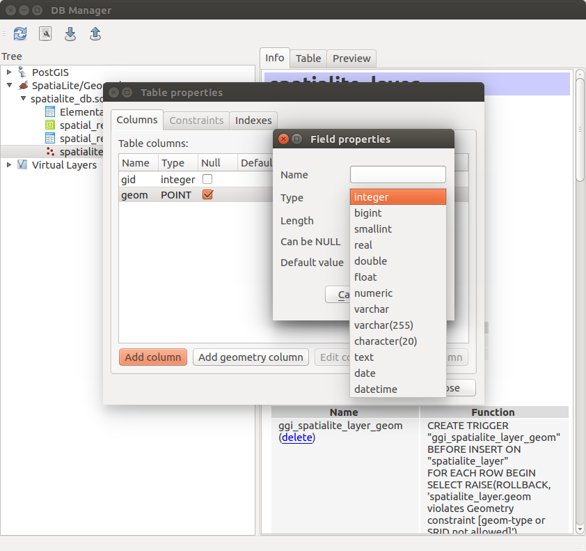
- File spatialite_edit_table.png added
#2
 Updated by Jukka Rahkonen about 10 years ago
I am not sure about this. While SQLite internally has only few datatypes it is still possible to create a column for example as
ALTER TABLE "foo"
ADD COLUMN "bar" varchar(20);
Now command PRAGMA table_info('foo') will show
bar varchar(20) 0 NULL 0
Even is is possible to store almost anything into "bar" the applications can still check the PRAGMA and get to know that they are supposed to save varchar(20) data into that column. Also, a roundtrip from for example PostGIS into SpatiaLite and back have better possibilities to be successful if datatypes are copied.
Compare also with GeoPackage which defines all these datatypes:
BOOLEAN, TINYINT, SMALLINT, MEDIUMINT, INT or INTEGER, FLOAT, DOUBLE or REAL, TEXT{(maxchar_count)}, BLOB{(max_size)}, <geometry_type_name>, DATE, DATETIME.
I consider this is not a bug.
I am not a QGIS developer, but some developers in some other projects which I know appreciate if things are first discussed on the mailing list and bug tickets are created only for issues which are recognized as bugs. Mailing lists are also followed by more people than issue trackers and those people may enjoy the discussion and learn something by the same.
#3
Updated by R. R. about 10 years ago
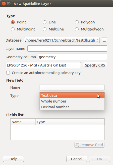
Hi Jukka, the 'New SpatiaLite Layer' dialog only lists the data types 'Text data', 'Whole number' and 'Decimal number' (see attachment). To me this looks like an inconsistency between the 'Manage Layers Toolbar' and the 'DB Manager'. As mentioned PostGIS and SpatiaLite differ in some points, but the design of the dialog windows in the 'DB-Manager' is almost identical.
#4
Updated by R. R. about 10 years ago
Jukka Rahkonen wrote:
I am not a QGIS developer, but some developers in some other projects which I know appreciate if things are first discussed on the mailing list and bug tickets are created only for issues which are recognized as bugs. Mailing lists are also followed by more people than issue trackers and those people may enjoy the discussion and learn something by the same.
I agree with that. There is a need for discussion about the SpatiaLite implementation in the 'DB Manager' .
#15082 SpatiaLite index issue
#15079 New PostGIS/SpatiaLite table - Inconsistent behavior of primary keys
Unfortunately I'm not a member of the mailing list at the moment.
#5
Updated by R. R. about 10 years ago
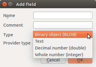
- File add_field_attribute_table.png added
The 'Add field' dialog (Attribute table/New field) lists the data types 'Binary object (BLOB)', 'Text', 'Decimal number (double)' and 'Whole number (integer)'.
#6
 Updated by Giovanni Manghi about 9 years ago
- Regression? set to No
- Easy fix? set to No
#7
Updated by Giovanni Manghi over 7 years ago
- Resolution set to end of life
- Status changed from Open to Closed
End of life notice: QGIS 2.18 LTR
Source:
http://blog.qgis.org/2019/03/09/end-of-life-notice-qgis-2-18-ltr/
QGIS 3.4 has recently become our new Long Term Release (LTR) version. This is a major step in our history – a long term release version based on the massive updates, library upgrades and improvements that we carried out in the course of the 2.x to 3x upgrade cycle.
We strongly encourage all users who are currently using QGIS 2.18 LTR as their preferred QGIS release to migrate to QGIS 3.4. This new LTR version will receive regular bugfixes for at least one year. It also includes hundreds of new functions, usability improvements, bugfixes, and other goodies. See the relevant changelogs for a good sampling of all the new features that have gone into version 3.4
Most plugins have been either migrated or incorporated into the core QGIS code base.
We strongly discourage the continued use of QGIS 2.18 LTR as it is now officially unsupported, which means we’ll not provide any bug fix releases for it.
You should also note that we intend to close all bug tickets referring to the now obsolete LTR version. Original reporters will receive a notification of the ticket closure and are encouraged to check whether the issue persists in the new LTR, in which case they should reopen the ticket.
If you would like to better understand the QGIS release roadmap, check out our roadmap page! It outlines the schedule for upcoming releases and will help you plan your deployment of QGIS into an operational environment.
The development of QGIS 3.4 LTR has been made possible by the work of hundreds of volunteers, by the investments of companies, professionals, and administrations, and by continuous donations and financial support from many of you. We sincerely thank you all and encourage you to collaborate and support the project even more, for the long term improvement and sustainability of the QGIS project.