Bug report #14183

Red channel ignored in freshly loaded raster file
| Status: | Closed | ||
|---|---|---|---|
| Priority: | Normal | ||
| Assignee: | |||
| Category: | Rasters | ||
| Affected QGIS version: | master | Regression?: | No |
| Operating System: | Easy fix?: | No | |
| Pull Request or Patch supplied: | No | Resolution: | |
| Crashes QGIS or corrupts data: | No | Copied to github as #: | 22185 |
Description
If I load rasters sometimes the Red-channel is not shown.
Debian Testing, QGIS Master and 2.8, self compiled here
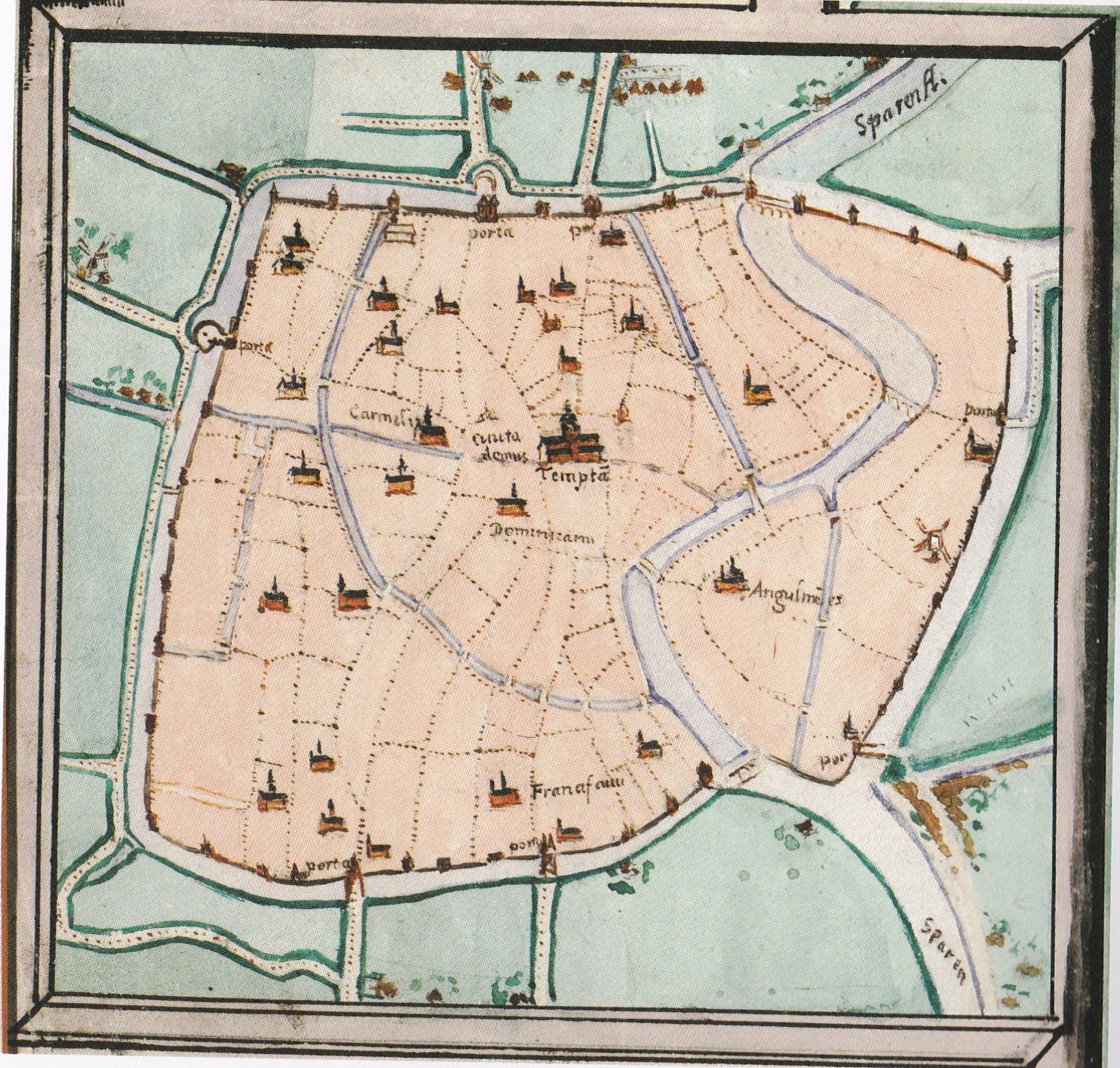
If I load the attached jpg file (an old map scan/image), it shows up greenish (as in My greenish map)...
Opening the properties of the file then, and going to style, I see render type: Multiband color, but
Red band is 'Not set'.
Setting it to Band 1 (Red) and my image shows up normal again.
Not sure what it is, I first thought it was my image, but now I have it with all images I load.
Below is gdalinfo of the attached image. Which also sees normal RGB bands??
It looks like it misses a channel at first or so?
gdalinfo van-deventer-1560.jpg
Driver: JPEG/JPEG JFIF
Files: van-deventer-1560.jpg
Size is 1624, 1549
Coordinate System is `'
Metadata:
  EXIF_ComponentsConfiguration=0x1 0x2 0x3 00
  EXIF_DateTime=2014:07:03 20:33:10
  EXIF_DateTimeDigitized=2014/07/03 20:27:36
  EXIF_DateTimeOriginal=2014:07:03 20:33:10
  EXIF_ExifVersion=0221
  EXIF_FlashpixVersion=0100
  EXIF_Make=Canon
  EXIF_Model=Canon MG3500 series Network
  EXIF_Orientation=1
  EXIF_PixelXDimension=1624
  EXIF_PixelYDimension=1549
  EXIF_ResolutionUnit=2
  EXIF_Software=My Image Garden
  EXIF_XResolution=(300)
  EXIF_YCbCrPositioning=1
  EXIF_YResolution=(300)
Image Structure Metadata:
  COMPRESSION=JPEG
  INTERLEAVE=PIXEL
  SOURCE_COLOR_SPACE=YCbCr
Corner Coordinates:
Upper Left  (    0.0,    0.0)
Lower Left  (    0.0, 1549.0)
Upper Right ( 1624.0,    0.0)
Lower Right ( 1624.0, 1549.0)
Center      (  812.0,  774.5)
Band 1 Block=1624x1 Type=Byte, ColorInterp=Red
  Overviews: 812x775, 406x388, 203x194
  Image Structure Metadata:
    COMPRESSION=JPEG
Band 2 Block=1624x1 Type=Byte, ColorInterp=Green
  Overviews: 812x775, 406x388, 203x194
  Image Structure Metadata:
    COMPRESSION=JPEG
Band 3 Block=1624x1 Type=Byte, ColorInterp=Blue
  Overviews: 812x775, 406x388, 203x194
  Image Structure Metadata:
    COMPRESSION=JPEG
History
#1
 Updated by Richard Duivenvoorde over 10 years ago
- File van-deventer-1560.jpg added
- File greenish.png added
#2
 Updated by Nyall Dawson over 10 years ago
- Assignee set to Nyall Dawson
#3
Updated by Nyall Dawson over 10 years ago
- Status changed from Open to Feedback
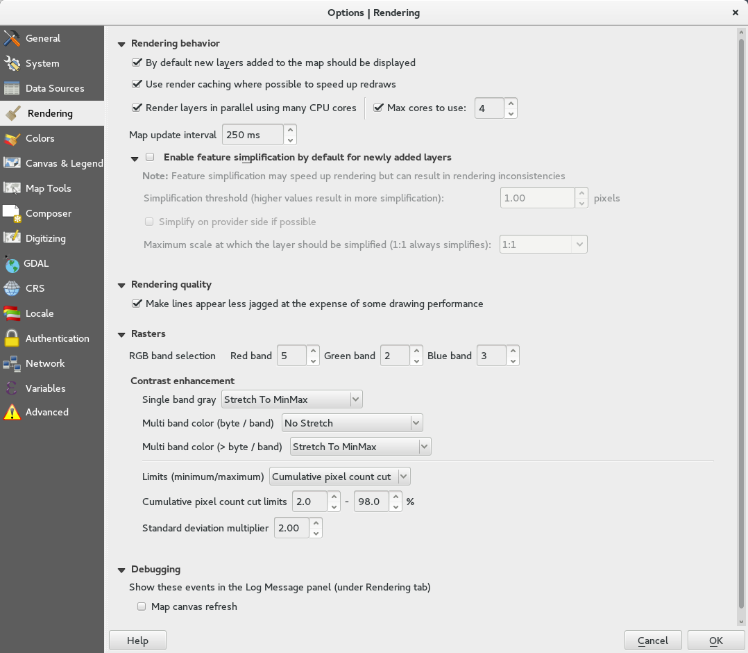
How often can you trigger this? Can you screenshot your raster settings from options?
#4
Updated by Richard Duivenvoorde over 10 years ago
- File Options___Rendering_025.png added
Hi Nyall, thanks for taking this.
It was 100% triggered, BUT... starting QGIS with a 100% fresh configuration with
qgis --config-path /tmp
it was ok...
Which make me look into the settings, and I found that in the 'Rendering' part I had apparently a 5 in the RGB bad selection...
Not sure where I got this one from though...
Is it possible to have a 5 there (for RGB) anyway?
Anyway, not an issue (anymore), will close it.
#5
Updated by Richard Duivenvoorde over 10 years ago
- Status changed from Feedback to Closed