Bug report #11746

Vertical lines appear as artifacts when map has lots of layers turned on.
| Status: | Closed | ||
|---|---|---|---|
| Priority: | Normal | ||
| Assignee: | - | ||
| Category: | Map Canvas | ||
| Affected QGIS version: | 2.6.0 | Regression?: | No |
| Operating System: | Easy fix?: | No | |
| Pull Request or Patch supplied: | No | Resolution: | |
| Crashes QGIS or corrupts data: | No | Copied to github as #: | 19979 |
Description
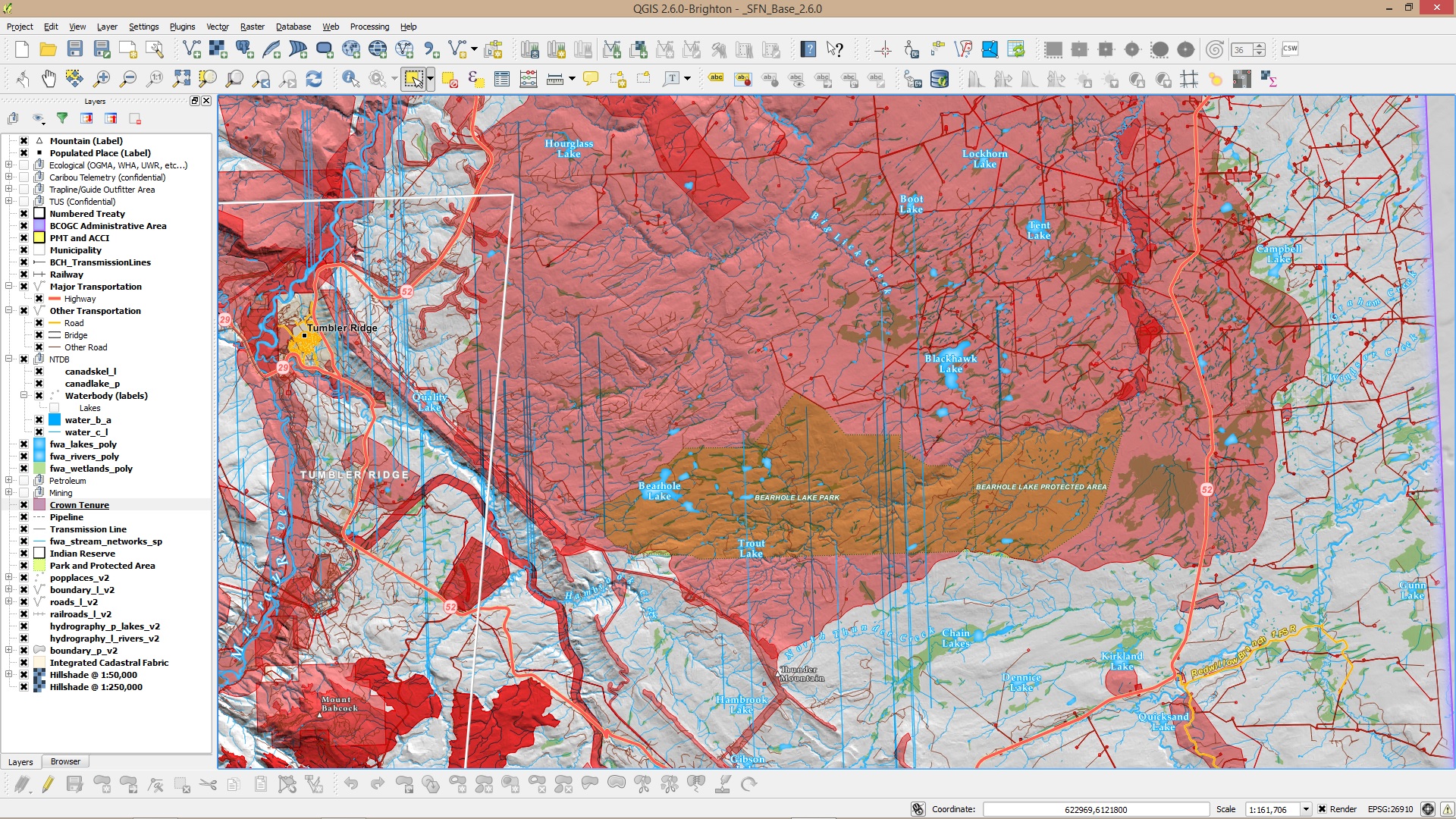
I've been noticing on Windows (haven't seen this problem in Linux), is that for maps that have lots of layers (50+) vertical lines start to appear from various layers. Always random and doesn't affect specific layers or different scales.
This happens to mostly to lines and polygons. Not sure if it's relevant but the layers are from a PostGIS database.
Feature simplification is turned off, tried testing with multi-core rendering toggled on/off as well.
Even though layers are turned on, most are scale based.
Installed QGIS 2.6 with OSGeo4W installer.
Related issues
Associated revisions
Put X field above Y field in Delimited Text dialog. Fix #11746.
History
#1
 Updated by Giovanni Manghi about 11 years ago
- Category set to Map Canvas
#2
 Updated by Donovan Cameron about 11 years ago
Been doing some more testing and it looks like it doesn't matter how many layers are in the project.
Even a single layer will do this when the "Render layers in parallel using many CPU cores" option is enabled.
Disabling that option fixes the issue.
Or reducing the number of cores used (on an 8 core Intel CPU i7) to 3 or less seems to reduce the artifacts. But they do appear randomly.
And this is only observed on Windows 7 and 8.1 x64 using the OSGeo4W installer. Haven't tested with standalone builds.
#3
Updated by Donovan Cameron about 10 years ago
Looks like it doesn't have anything to do with the amount of layers and it's only on Windows (7 and 8.1 64-bit) from OSGeo4W.
Tested on Arch Linux and can't reproduce there, but those are daily builds from the 2_12 branch.
So on Windows, we're able to reproduce the issue by adding a couple layers (from PostgreSQL 9.4.5 and PostGIS 2.2.0) in EPSG:3005 (BC Albers), then enabling OTF to something like EPSG:26910.
Then once we start panning and zooming the vertical lines appear like in the screenshot originally attached.
I'll test QGIS Master on Windows from the OSGeo4W installer and report back =)
Turning off multi-core rendering will reduce the artifacts and frequency, but not entirely.
#4
Updated by Donovan Cameron about 10 years ago
Seeing the same rendering issues in Master (2.13.0, 3e61891) and Current Release (2.12.0, cd9d645) on Windows from OSGeo4W.
I can add a few layers in EPSG:3005, then turn OTF on to anything like EPSG:26910 and vertical lines appear.
#5
 Updated by Nyall Dawson about 10 years ago
- Status changed from Open to Feedback
Can you share your data? Has it got Z/M coordinates?
#6
Updated by Donovan Cameron about 10 years ago
Some of the most culprit layers can be obtained from public FTPs in BC.
Large files though (they're province wide), and I've uploaded them to PostGIS databases using gdal forcing 2D with '-dim 2' because no layers contain z-values but some layers will be used for topology (routing) later, but currently no M values.
Invalid geometries have been repaired too.
Road Network
ftp://ftp.geobc.gov.bc.ca/sections/outgoing/bmgs/DRA_Public/dgtl_road_atlas.gdb.zip (256 MB)
Fresh Water Atlas
ftp://ftp.geobc.gov.bc.ca/sections/outgoing/bmgs/FWA_Public/FWA_BC.gdb.zip (3.5 GB)
The Fresh Water Atlas has a good mix of layers that have different types of geometries like lakes/rivers (polygon), stream network (line), wetland (polygon), etc. Load at least those 3 layers (and the road network mpar layer) to see the vertical lines. These layers seem to be doing it the most (maybe it's because they have the most nodes?).
#7
Updated by Donovan Cameron about 10 years ago
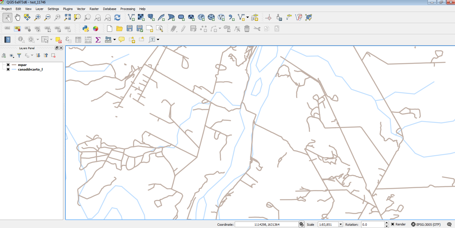
I'm able to reproduce it easily now =)
I add the Digital Road Atlas (layer that ends in mpar) which is in EPSG:3005.
Then I add some layers from ftp://ftp2.cits.rncan.gc.ca/pub/geott/frameworkdata/hydrology/cartographic/canada/canaddrcarto_1m_v6-0.shp.zip (94.4 MB) which are some water course and body layers but in EPSG:4269 so that turns OTF on (projecting to EPSG:3005).
Then I can see the vertical lines from the water course and body layers.
This means you might not have to download the FWA dataset to test it out.
#8
Updated by Giovanni Manghi about 10 years ago
- File 11746.png added
Donovan Cameron wrote:
I'm able to reproduce it easily now =)
I add the Digital Road Atlas (layer that ends in mpar) which is in EPSG:3005.
Then I add some layers from ftp://ftp2.cits.rncan.gc.ca/pub/geott/frameworkdata/hydrology/cartographic/canada/canaddrcarto_1m_v6-0.shp.zip (94.4 MB) which are some water course and body layers but in EPSG:4269 so that turns OTF on (projecting to EPSG:3005).
Then I can see the vertical lines from the water course and body layers.
This means you might not have to download the FWA dataset to test it out.
no problems here under Windows 7/QGIS master, see attached image
You can also want to test the linked project + data (to avoid having to download that big datasets referred above).
https://www.dropbox.com/s/dlphmmqpjvb0xwe/test_11746.zip?dl=0
#9
Updated by Giovanni Manghi about 10 years ago
- Status changed from Feedback to Closed
- Resolution set to worksforme
closing for lack of feedback, please reopen of necessary.
#10
Updated by Donovan Cameron about 10 years ago
- File vertical_lines_noplugins_nocustomization.png added
Thanks for testing Giovanni.
I've uploaded something similar in 7z and zip - both the same and with the full datasets, but with a project file like yours.
https://dl.dropboxusercontent.com/u/33592962/outgoing/qgis/qgis_vertical_lines.zip (120MB)
https://dl.dropboxusercontent.com/u/33592962/outgoing/qgis/qgis_vertical_lines.7z (86MB)
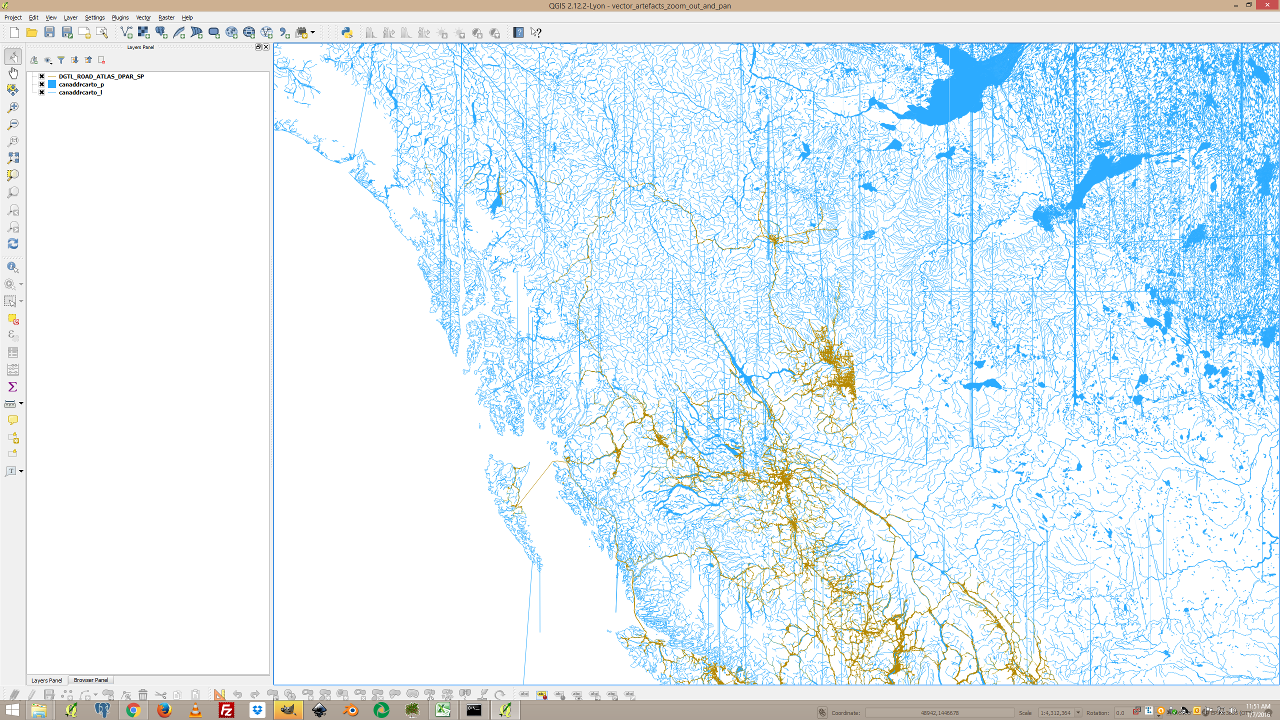
I noticed the vertical lines are really coming out when there are only a couple layers and zoomed out. I attached an image.
Or if there are lots of layers, when zoomed in.
I loaded the project in QGIS and QGIS Master (installed from OSGeo4W) using the --noplugins --nocustomization options to be sure it wasn't a rogue plugin or customization.
Getting the same result on both Windows 8.1/7 64bit.
Linux is working great where I don't see any artefacts, but there are lots of "Warnings" in the console.
Warning: Could not resolve property : linearGradient4548
...
#11
Updated by Donovan Cameron about 10 years ago
- Status changed from Closed to Reopened
Forgot to reopen so that's what this post is for.
#12
Updated by Giovanni Manghi about 10 years ago
- Resolution deleted (
worksforme)
#13
Updated by Donovan Cameron about 10 years ago
I also noticed that the problem almost completely disappears when "Render layers in parallel using many CPU cores" is turned off.
There is still the rare vector off shoot problem from both lines and polygons but now it seems to only show one or two artefacts, and then a pan or refresh gets rid of it for a good while.
I noticed it's also re-drawing the geometries.
So a line that was like ......... now looks like ..../\\....
So it's like it's moving nodes/vertices around for some reason.
#14
 Updated by Martin Dobias about 10 years ago
- Status changed from Reopened to Feedback
#15
Updated by Donovan Cameron almost 10 years ago
- Status changed from Feedback to Closed
Hey Martin, seems to still exist in 2.14.0 (Essen), so I'll close this report because it is a duplicate and follow the progress on the other report.