Bug report #710

Shapefiles not matching up with satellite imagery, even though both are WGS84
| Status: | Closed | ||
|---|---|---|---|
| Priority: | Low | ||
| Assignee: | |||
| Category: | Vectors | ||
| Affected QGIS version: | Regression?: | No | |
| Operating System: | Debian | Easy fix?: | No |
| Pull Request or Patch supplied: | Resolution: | worksforme | |
| Crashes QGIS or corrupts data: | Copied to github as #: | 10769 |
Description
Steps to reproduce:
1. Layer > Add WMS Layer
 2. Select NASA (JPL) and click "Connect"
 3. Click "global_mosaic" and click "Add"
 4. Zoom in, e.g. (-8,60)(2,52)
 5. Layer -> Add a Vector Layer
 6. Double-click a shapefile (I'm trying to use SRTM Water Body Dataset shapefiles, e.g. "w005n57e.shp", downloaded from "ftp://e0srp01u.ecs.nasa.gov/srtm/version2/SWBD/")
What happens:
The shapefile is displayed, but in the wrong place and the wrong size, i.e. the vector outline of water bodies does not match the water bodies visible in the satellite image.
Extra information:
- OS: Ubuntu 7.04
- Hardware: Pentium M 1.8, 1GB RAM
- QGIS Version: 0.8.0 (Ubuntu packages from download.qgis.org, to get them to install I had to install libgdal1-1.3.1-6 from Ubuntu 6.10.)
- I have checked the reference system in the properties of each layer, and the project properties. They are all WGS84.
History
#1
 Updated by Gary Sherman almost 19 years ago
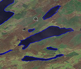
What sort of offset are you seeing. It seems to work fine for me (see attached graphic)
#2
 Updated by pcavallini - almost 19 years ago
eskea, could you please check, and close the bug if it does no longer apply?
Thanks.
#3
Updated by Gary Sherman over 18 years ago
- Resolution set to worksforme
- Status changed from Open to Closed
No further information after 7 months -- appears to work so closing this bug.
#4 Updated by Anonymous over 16 years ago
Milestone Version 0.8.2 deleted