Bug report #653

Misplaced WMS layers
| Status: | Closed | ||
|---|---|---|---|
| Priority: | Low | ||
| Assignee: | |||
| Category: | Web Services clients/WMS | ||
| Affected QGIS version: | Regression?: | No | |
| Operating System: | Windows | Easy fix?: | No |
| Pull Request or Patch supplied: | Resolution: | fixed | |
| Crashes QGIS or corrupts data: | Copied to github as #: | 10712 |
Description
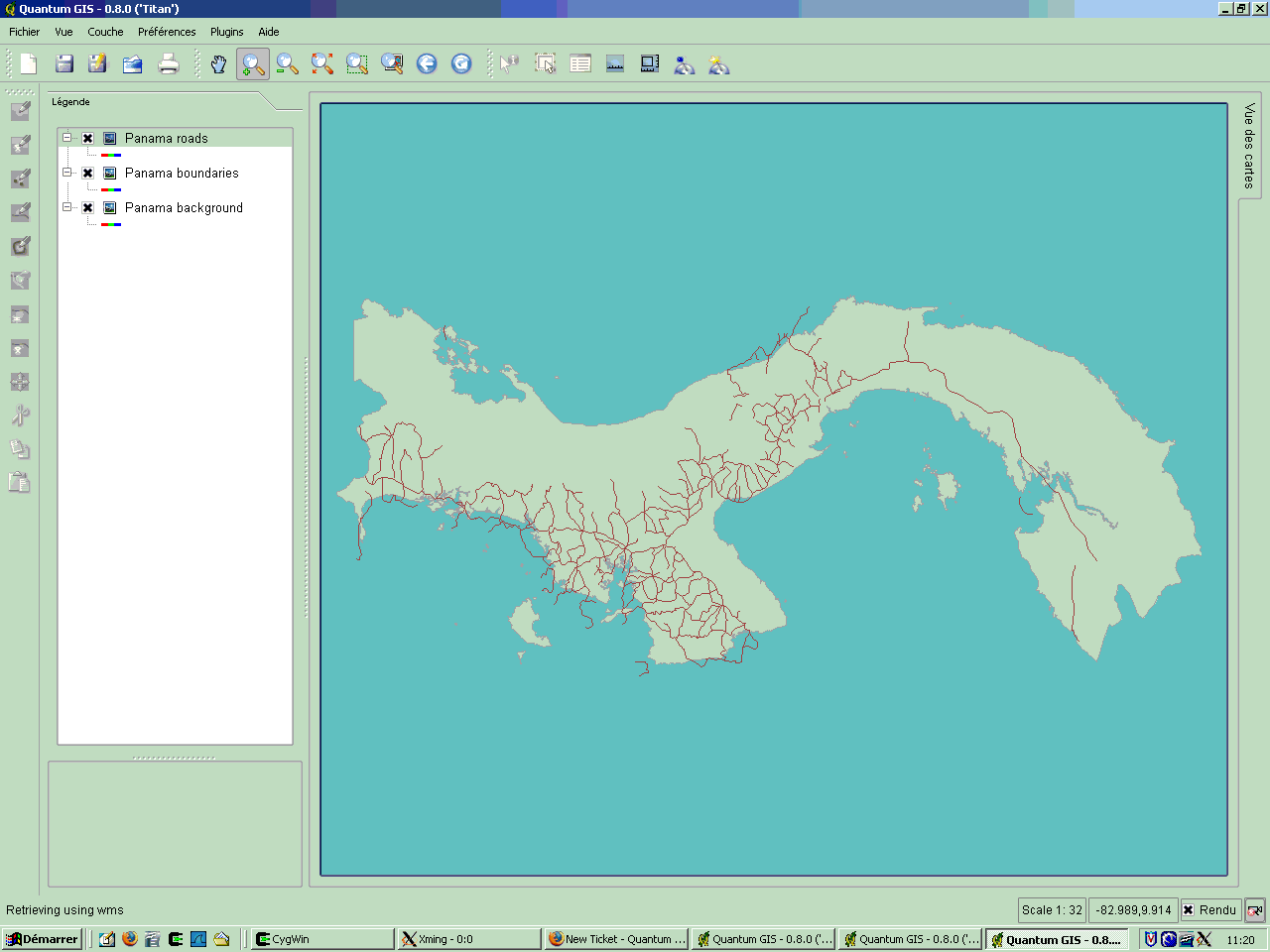
Adding two WMS layers in QGis produces bad output.
In the screenshot, I have 3 layers correspond to 3 unique WMS layers. The background and the boundaries are created from the same dataset (ponet/PAL.shp) whereas the roads are created from their own set (rdline/ARC.shp)
While the background and the boundaries are perfectly aligned, the roads aren't.
NB: Sorry for the poor quality of the screenshot.
History
#1
 Updated by Magnus Homann almost 19 years ago
Could you please include the adress to the layers, if available?
Also, did you use the 8.1 preview version, and what projection did you set?
#2
 Updated by myardbenoit-gmail-com - almost 19 years ago
Could you please include the adress to the layers, if available?
Sorry but our MapServer installation is not accissible through the Internet. I could provide you a set Shapefiles, our server's capabilities or even an excerpt of the configuration (ie. don't hesitate to ask).
Also, did you use the 8.1 preview version [...]
Altough you can read 0.8.0 on the screenshot, I tested and encountered this bug on both 0.8.0 and 0.8.1 (preview 2 available at http://qgis.org/uploadfiles/testbuilds/).
[...] , and what projection did you set?
I was using EPSG:4008 latlong projection and Clarke 1866 ellipsoid both on the server-side and the client-side.
What makes me think this is a QGis related bug is that when you request the 3 WMS layers in a single request (only 1 layer visible in QGis), the roads are well aligned.
#3
Updated by myardbenoit-gmail-com - almost 19 years ago
Seems to be a Windows build related bug. I couldn't reproduce it under Linux with QGis while I did reproduce it on another Windows box.
I will attach a simple example (MapServer configuration & data) for you to reproduce this behavior.
Remember that you have to add the two WMS separately.
#4
Updated by myardbenoit-gmail-com - almost 19 years ago
Seems like my tarball is too big. You can fetch it here : http://taudis.fr/stuff/panama.tar.gz
#5
Updated by Magnus Homann almost 19 years ago
- Status changed from Open to Closed
- Resolution set to worksforme
Thanks for the mapserver files!
I get the same error when trying 0.8.0 on Win2K.
On 0.8.1preview2 this works on Win2K, however.
Also works in CVS snapshot on Win2K.
0.8.1 must be installed in a clean directriy, no traces of 0.8.0 should remain. If it still doesn't work for you, please re-open the bug.
#6
Updated by myardbenoit-gmail-com - almost 19 years ago
- Status changed from Closed to Feedback
- Resolution deleted (
worksforme)
I'm sorry, but it doesn't work for me (Win XP, QGis 0.8.1preview2, fresh install).
#7
Updated by Magnus Homann almost 19 years ago
You're right. I've spent hours trying different versions on both Win2K and XP, and 0.8.1per2 doesn't work correctly on either of them. Checking out latest from SVN and compiling does however work.
Wait until next preview/final and see if it works. Until then, we can leave this open.
#8
Updated by Magnus Homann almost 19 years ago
Try:
http://qgis.org/uploadfiles/testbuilds/qgis_setup0.8.1preview3.exe
Remember to uninstall old versions!
#9
Updated by myardbenoit-gmail-com - almost 19 years ago
- Status changed from Feedback to Closed
- Resolution set to fixed
It works flawlessly now! Amazing job, thanks.
#10 Updated by Anonymous over 16 years ago
Milestone Version 0.8.1 deleted