Bug report #6302

QGIS WFS Server Geometry Type not recognize by ArcGIS
| Status: | Closed | ||
|---|---|---|---|
| Priority: | Normal | ||
| Assignee: | |||
| Category: | QGIS Server | ||
| Affected QGIS version: | master | Regression?: | No |
| Operating System: | Easy fix?: | No | |
| Pull Request or Patch supplied: | Yes | Resolution: | fixed |
| Crashes QGIS or corrupts data: | No | Copied to github as #: | 15598 |
Description
After the resolution of #6116, Giovanni Manghi testing QGIS WFS Server with GvSIG, uDIG and ArcGIS.
ArcGIS doesn't recognize the Geometry Type, because ArcGIS uses DescribeFeatureType to identifying Geometry Type and QGIS WFS Server return that geometry is just GeometryPropertyType.
Subtasks
Related issues
History
#1
 Updated by René-Luc ReLuc over 13 years ago
- File 6302 added
#2
 Updated by Giovanni Manghi over 13 years ago
The DescribeFeature Request is different in Mapserver and QGIS server. The Mapserver service works fine also on Arcgis and uDig.
here is mapserver
here is qgis server
#3
Updated by Giovanni Manghi over 13 years ago
- Pull Request or Patch supplied changed from No to Yes
#4
Updated by René-Luc ReLuc over 13 years ago
- File 6302_v2 added
In addition to indicate the geometry type in the DescribeFeatureType request, this patch adds boundedBy to FeatureCollection and Feature element.
#5
Updated by Giovanni Manghi over 13 years ago
René-Luc ReLuc wrote:
In addition to indicate the geometry type in the DescribeFeatureType request, this patch adds boundedBy to FeatureCollection and Feature element.
thanks! I will try it asap. Can you make a pull request on github?
#6
Updated by René-Luc ReLuc over 13 years ago
commit 593da452193f31d3941b56a64369c692b866bf40
for patch V2
#7
Updated by Giovanni Manghi over 13 years ago
René-Luc ReLuc wrote:
commit 593da452193f31d3941b56a64369c692b866bf40
for patch V2
Hi René-Luc,
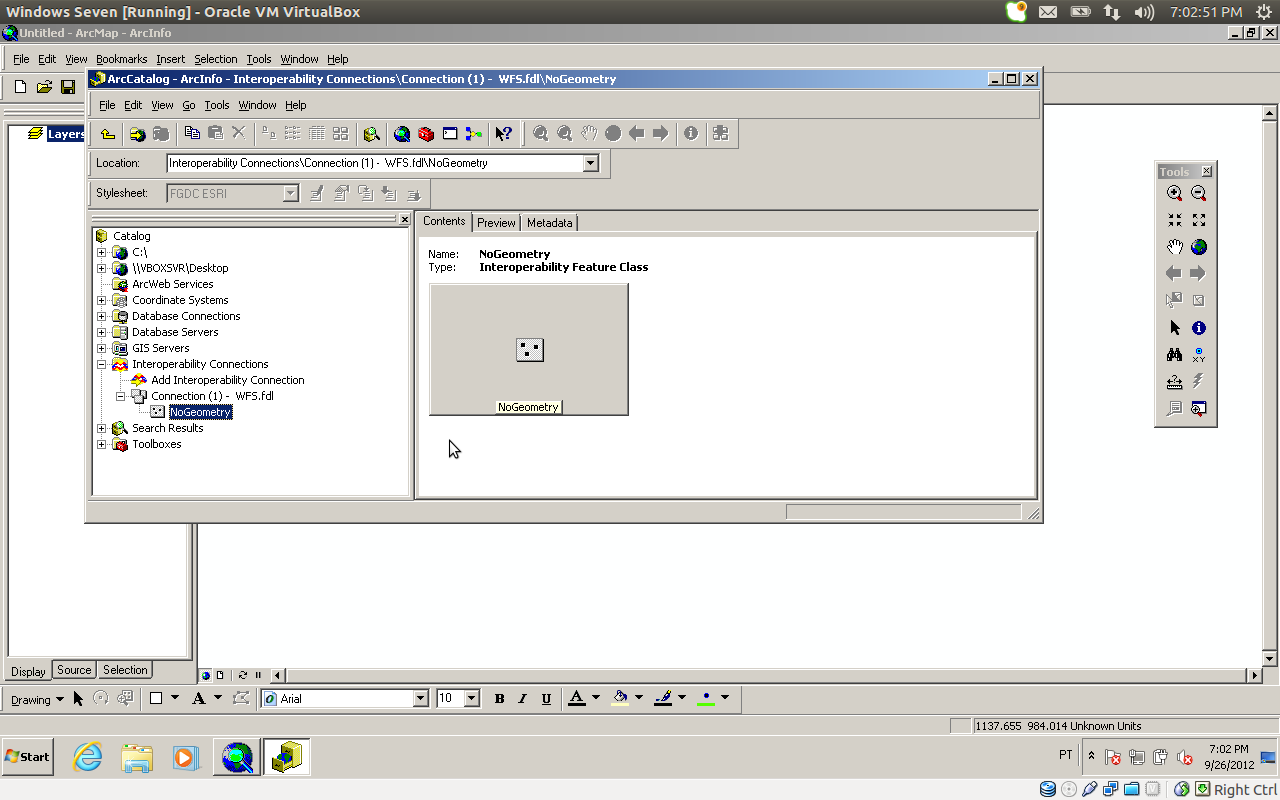
I have just installed qgis master and made a simple WFS service, then tested it with Arcgis 9.3 with the data interoperability extension.
When creating the connection AG shows the layer list correctly, but then it just show a "no geometry". See attached images.
#8
Updated by René-Luc ReLuc about 13 years ago
This new commit "0ddc034968065046f301d260900d6e9fa46d2ef0":commit:0ddc034968065046f301d260900d6e9fa46d2ef0 probably solved tue issue
#9
Updated by Giovanni Manghi about 13 years ago
René-Luc ReLuc wrote:
This new commit "0ddc034968065046f301d260900d6e9fa46d2ef0":commit:0ddc034968065046f301d260900d6e9fa46d2ef0 probably solved tue issue
Hi Again René-Luc,
I just tested again the latest QGIS master available in the nightly build repo, and unfortunately still no joy with AG as WFS client.
The issue is always the same, it shows the table list, but then when establishing the connection (to actually choose what layer to add to the project) it just says "no geometry".
cheers!
#10
Updated by René-Luc ReLuc over 12 years ago
Giovanni Manghi : does the bug still exists ?
#11
Updated by René-Luc ReLuc over 12 years ago
- Resolution set to fixed
- Status changed from Open to Closed