Bug report #21729

Reprojection not working on Mapinfo tabfiles
| Status: | Feedback | ||
|---|---|---|---|
| Priority: | Normal | ||
| Assignee: | - | ||
| Category: | Vectors | ||
| Affected QGIS version: | 3.4.5 | Regression?: | No |
| Operating System: | Easy fix?: | No | |
| Pull Request or Patch supplied: | No | Resolution: | |
| Crashes QGIS or corrupts data: | No | Copied to github as #: | 29544 |
Description
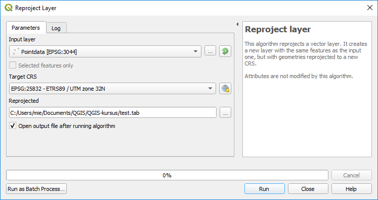
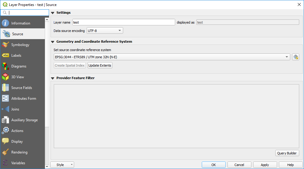
I have a mapinfo-tab file in coordinate system EPSG:3044. I want to reproject it to EPSG:25832, and keep it as a mapinfo-file.
I have tried various ways to reproject the file to the new coordinate system, among other the 'Reproject Layer'-tool where I select Tab-files as the output format.
The tool runs without any problem, but the coordinatsystem in the new reprojected layer is the still EPSG 3044 - and not EPSG25832.
It works fine if I reproject to a shapefile.
The same happens in the export-function from the layer properties.
I have attached two screenshots and the tab-file
History
#1
 Updated by Giovanni Manghi almost 7 years ago
- Operating System deleted (
Windows) - Status changed from Open to Feedback
- Category changed from Processing/QGIS to Vectors
The same thing happens when using ogr2ogr, i.e.
ogr2ogr -f "MapInfo File" output1.tab Pointdata.tab -s_srs EPSG:3044 -t_srs EPSG:3857
so it is unlikely to be a QGIS bug.
#2
 Updated by Mie Winstrup almost 7 years ago
Giovanni Manghi wrote:
The same thing happens when using ogr2ogr, i.e.
ogr2ogr -f "MapInfo File" output1.tab Pointdata.tab -s_srs EPSG:3044 -t_srs EPSG:3857
so it is unlikely to be a QGIS bug.
Okay, then I should probably report the issue to ogr2ogr, and close this issue?
#3
Updated by Giovanni Manghi almost 7 years ago
Mie Winstrup wrote:
Giovanni Manghi wrote:
The same thing happens when using ogr2ogr, i.e.
ogr2ogr -f "MapInfo File" output1.tab Pointdata.tab -s_srs EPSG:3044 -t_srs EPSG:3857
so it is unlikely to be a QGIS bug.
Okay, then I should probably report the issue to ogr2ogr, and close this issue?
I would say yes, but let's see if a developer has something to say.