Bug report #21063

Unable to load GFS weather grib2 format data as a mesh
| Status: | Closed | ||
|---|---|---|---|
| Priority: | Normal | ||
| Assignee: | - | ||
| Category: | Data Provider/MDAL | ||
| Affected QGIS version: | 3.4.1 | Regression?: | No |
| Operating System: | MacOSX 10.14.2 | Easy fix?: | No |
| Pull Request or Patch supplied: | No | Resolution: | no timely feedback |
| Crashes QGIS or corrupts data: | No | Copied to github as #: | 28881 |
Description
I did some reading on MDAL and tried the instructions found at:
https://www.lutraconsulting.co.uk/blog/2018/10/18/mdal/trying to load a GFS weather grib2 dataset containing u and v 10 meter height wind components as a mesh instead of a raster, and I get the following error message:
Tools::BufferedFileWriter::open: Cannot open file.: unspecified iostream_category errorI also tried loading the ECMWF_ERA-40_subset.nc dataset linked to the blog post and get an error message saying it is an invalid data source.
I’m using QGIS version 3.4.1-Madeira on MacOSX 10.14.2
The GFS input file is attached. The ECMWF_ERA-40_subset.nc dataset is too large to attache, but is at:
https://www.unidata.ucar.edu/software/netcdf/examples/ECMWF_ERA-40_subset.nc
History
#1
 Updated by Lee Eddington almost 7 years ago
Also, the GFS file loads fine as a raster.
#2
 Updated by Saber Razmjooei almost 7 years ago
- File Screenshot_20190122_073332.png added
- Status changed from Open to Feedback
Hi Lee,
I tried both files and they work with QGIS master (and MDAL master).
I know there is a missing hdf in QGIS macOS from the official QGIS download. Could you try:
https://lutraconsulting.github.io/qgis-mac-packager/
I suggest to first try it with QGIS 3.4.4.
#3
 Updated by Peter Petrik almost 7 years ago
could be related/duplicate of https://github.com/lutraconsulting/MDAL/issues/72. Can you try as admin?
#4
 Updated by robert kalasek almost 7 years ago
same here !
tested both - gfs and the ecmwf
on mac qgis 3.4.4 ("compiled against gdal 2.3.3"): gfs and ecmwf
gfs -> error message "Tools::BufferedFileWriter::open: Cannot open file.: unspecified iostream_category error",
ecmwf -> error message "invalide data source"
on win qgis 3.4.4 ("compiled against gdal 2.4.0"): crash while loading the gfs-file
test with arcgis 10.6:
gfs: no problem
ecwmf: format not supported
the following page lists a number of netCDF data files: https://www.unidata.ucar.edu/software/netcdf/examples/files.html ... none of them were recognized as valide datasources.
#5
Updated by Saber Razmjooei almost 7 years ago
Could you try it in QGIS 3.6 in Windows and macOS. QGIS 3.6 for macOS will be ready shortly:
https://lutraconsulting.github.io/qgis-mac-packager/
We have done some main changes to mdal and not backported to QGIS 3.4. So, for mesh layer, best using the latest version of QGIS.
#6
Updated by robert kalasek almost 7 years ago
just figured out that
at 3.4.4 loading netCDF files
- doesn't work like it was mentioned somewhere ... via data source manager / mesh
- browser shows netCDF files - but displays two or three entries per data-file. one with a mesh symbol the other with a raster symbol, and a table symbol. the raster symbol works, the table covers the time-frame.
#7
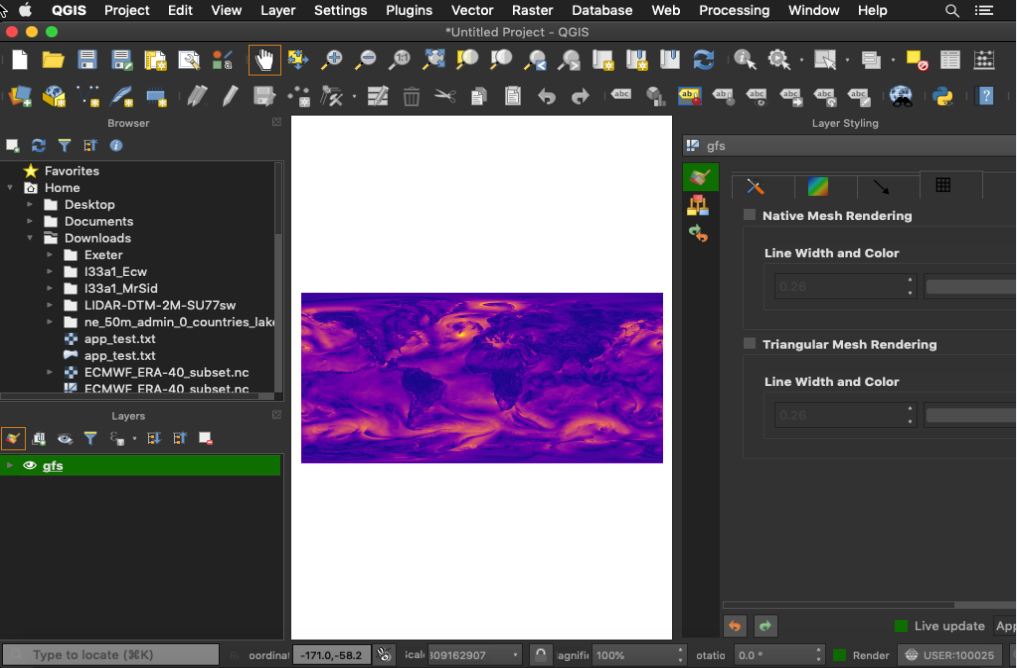
Updated by Saber Razmjooei almost 7 years ago
- File Screenshot_20190223_091737.png added
I am a bit lost. Because I can't replicate the issue on macOS 3.4.5 (https://lutraconsulting.github.io/qgis-mac-packager/).
I can open the attached gfs file (see attached). The only issue is that I can only open it via Data Source. It is not possible to open the gfs file as a mesh through the browser, because it does not have one of the known extensions (e.g. nc, grb, grib, etc).
To help closing this ticket as by the OP (macOS and nc file issue), could you,
1- Install QGIS 3.4.5 or 3.6 (https://www.dropbox.com/sh/w43am79lkx716p0/AADD9T4Fu7Ml-N0K4_Un964Aa/qgis_ltr_final-3_4_5_20190222_082309.dmg?dl=0 or https://www.dropbox.com/sh/qcr9a6ry25n4x91/AACoFpx3gw4mzOmhud4Ue4jHa/qgis_pr_final-3_6_0_20190222_124710.dmg?dl=0)
2- From the main menu, click on Layer > Data Source Manager
3- In the new window, from the left panel, click on Mesh
4- Point the browser to: https://issues.qgis.org/attachments/download/14133/gfs.t12z.pgrb2.0p25.f012 or https://www.unidata.ucar.edu/software/netcdf/examples/ECMWF_ERA-40_subset.nc
Let me know if you get any errors from the above procedure.
#8
 Updated by Giovanni Manghi almost 7 years ago
- Assignee deleted (
Lee Eddington)
#9
Updated by Giovanni Manghi almost 7 years ago
- Resolution set to no timely feedback
- Status changed from Feedback to Closed
Closing for lack of feedback. Please reopen if necessary.