Bug report #11291

WMTS time dimension does not work
| Status: | Closed | ||
|---|---|---|---|
| Priority: | Normal | ||
| Assignee: | - | ||
| Category: | Web Services clients/WMS | ||
| Affected QGIS version: | master | Regression?: | No |
| Operating System: | Easy fix?: | No | |
| Pull Request or Patch supplied: | No | Resolution: | end of life |
| Crashes QGIS or corrupts data: | No | Copied to github as #: | 19587 |
Description
I'm trying to display the MODIS satellite images from the GIBS image server (https://earthdata.nasa.gov/about-eosdis/science-system-description/eosdis-components/global-imagery-browse-services-gibs)
1) I select "Add WMS / WMTS layer"
2) I select "New" and add the server URL: http://map1.vis.earthdata.nasa.gov/wmts-geo/wmts.cgi?
3) I select the layer MODIS_Aqua_CorrectedReflectance_TrueColor
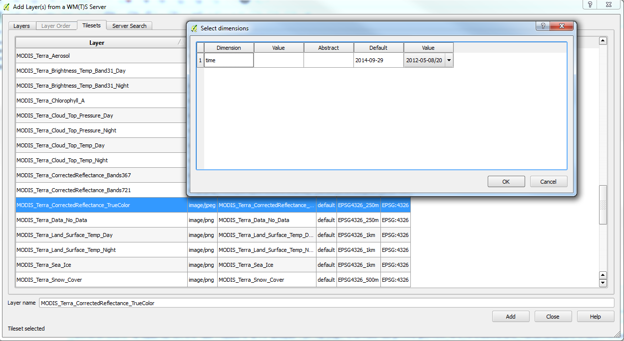
4) A Window "Select dimensions" appears with columns Dimension, Value, Abstract, Default and Value. The Value should show a drop-down of dates. But it doesn't show it. There's only one choice "2012-05-08/2014-09-29/P1D" and I can't select the date in the drop down.
5) When I click OK, nothing shows up on the map because the time dimension hasn't been set properly.
Please see the attachment. I think the drop-down should show a list of dates between 2012-05-08 and 2014-09-29.
History
#1
 Updated by Giovanni Manghi almost 12 years ago
- Affected QGIS version changed from 2.4.0 to master
- Category set to Web Services clients/WMS
- Target version set to Future Release - Nice to have
#2
 Updated by Matthew Cechini over 9 years ago
How do we discuss getting this onto the roadmap for QGIS? The NASA GIBS system referenced has nearly 400 imagery layers available via WMTS access. However, they are essentially unusable within QGIS because of this issue with the time dimension. The GetCapabilities document identifies the 'time' dimension in compliance with Annex C of the WMS 1.3.0 specification, specifically using the "min/max/resolution" nomenclature. At a minimum, it would be nice to be able to edit the date per layer and to have that correctly provided within the WMTS request. As a stretch goal, it would be nice to be able to enter that date somewhere within the QGIS interface such that it could be applied to multiple layers at the same time.
#3
Updated by Giovanni Manghi about 9 years ago
- Regression? set to No
- Easy fix? set to No
#4
Updated by Giovanni Manghi over 7 years ago
- Resolution set to end of life
- Status changed from Open to Closed
End of life notice: QGIS 2.18 LTR
Source:
http://blog.qgis.org/2019/03/09/end-of-life-notice-qgis-2-18-ltr/