Bug report #1115

WMS Layer GetMap Request with Wrong Parameters
| Status: | Closed | ||
|---|---|---|---|
| Priority: | Low | ||
| Assignee: | |||
| Category: | Build/Install | ||
| Affected QGIS version: | Regression?: | No | |
| Operating System: | Debian | Easy fix?: | No |
| Pull Request or Patch supplied: | Resolution: | fixed | |
| Crashes QGIS or corrupts data: | Copied to github as #: | 11175 |
Description
WMS Request doesn't work as expected with a different projection than EPSG:4326.
The parameters BBOX and WIDTH and HEIGHT doesn't match with the SRS parameter. It doesn't match either with the projection of the map.
Here is the url of the WMS : http://www.geosignal.org/cgi-bin/wmsmap?
The projection of the map is 27582 : NTF (Paris)/France II and all the layers included the WMS layer are in this projection.
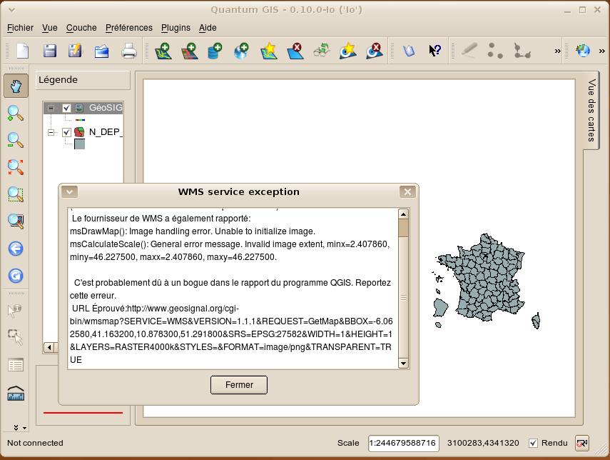
Here is the error of QGIS :
Ne peut dessiner GéoSIGNAL parce que:
(code d'erreur inconnu d'un serveur de post-1.3 WMS)
 Le fournisseur de WMS a également rapporté:
msDrawMap(): Image handling error. Unable to initialize image.
msCalculateScale(): General error message. Invalid image extent, minx=2.407860, miny=46.227500, maxx=2.407860, maxy=46.227500.

  C'est probablement dû à un bogue dans le rapport du programme QGIS. Reportez cette erreur.
 URL Éprouvé:http://www.geosignal.org/cgi-bin/wmsmap?SERVICE=WMS&VERSION=1.1.1&REQUEST=GetMap&BBOX=-6.062580,41.163200,10.878300,51.291800&SRS=EPSG:27582&WIDTH=1&HEIGHT=1&LAYERS=RASTER4000k&STYLES=&FORMAT=image/png&TRANSPARENT=TRUE
Indeed, the url should be :
http://www.geosignal.org/cgi-bin/wmsmap?SERVICE=WMS&VERSION=1.1.1&REQUEST=GetMap&BBOX=0,1600000,1250000,2600000&SRS=EPSG:27582&WIDTH=500&HEIGHT=400&LAYERS=RASTER4000k&STYLES=&FORMAT=image/png&TRANSPARENT=TRUE
Qgis set a good SRS (EPSG:2758) but the BBOX is false.
History
#1
 Updated by Marco Hugentobler over 17 years ago
- Resolution set to fixed
- Status changed from Open to Closed
I tried to load the layer Raster4000k and it works as expected with the current development version (both with selecting wgs84 or epsg 27582), resulting in the following request.
Please test and reopen the bug if it still occurs for you with the current devel version (or the rc version for 0.11.0 that should appear soon)
Regards,
Marco
#2 Updated by Anonymous over 16 years ago
Milestone Version 1.0.0 deleted