Spatial-query-tool, ideas and specs to refactor current tool
Topic has been initiated on lists "here [0]": http://osgeo-org.1560.n6.nabble.com/Spatial-queries-plugin-should-ignore-very-small-intersections-td5025788.html
Analyse of other equivalent tools and UI:
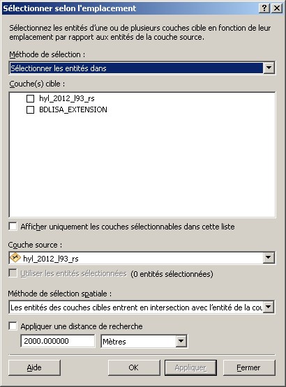
Analyse of Arcgis spatial query tool:
UI overview: 
- Selection methods (multiple layers can be put as targets) :
Create new selection
add to current selection
remove from selection
select from selection
source layer choice + option to use only selected objects of source layer
- spatial query method
target intersects source ( +3d option)
target is in distance of source + distance parameter + units
targets include source
targets entirely include source
targets are within source
targets are entirely within source
targets touches sources (share a boundary)
targets shares a line segments
targets are crosses by source boundary
targets have their centroid inside source
IMHO, the only drawback is to have spatial selection methods well understood by common end user. I really liked Geoprocessing wizard that showed little pictures for each rule. We could have a floating panel of that kind (drawn better of course)
